Went to finish the "boat house" area today and saw that raccoon again. It was lying next to the same tree he used to hide under. Dead.
Tuesday, December 30, 2008
Monday, December 29, 2008
Mapping in Fred G Bond Metro Park. Part 1
As I promised before, here is the first part of my "mapping in the Bond park" saga. Comparing with the map refresh I did in Schenck forest a year ago, this one (though a refresh too) proved to be much more difficult. I think I already spent as much time in the Bond park as I did in Schenck forest and I am only about 50% done. There were several things that complicated this map refresh work for me:
- The base map was indeed very old and outdated. Not only the trails has changed, but also vegetation and terrain.
- There were several big construction projects completed after the base map was created. Community Center, Seniors Center, new boat house, new parking lots had to be added to the map along with appropriate changes in elevation lines.
- This time I decided to map vegetation (white/green/dark green areas as well as fallen trees), which I didn't do in Schenck forest.
Anyway, here is what I did (step by step):
1. November 5
Went to the park and talked to Tracy (park's manager?). She gave me permission to map the park and in general was very supportive. She would love to have a new map with a set of their fixed controls plotted on it. She also gave preliminary OK for our sprint event next year.
Then walked around the park and compared it to the base map. Oh, boy. So many new constructions! Also noticed that the dam at the lake was plotted on the base map 5-7 degrees off! Here is a portion of the base map which was updated the most.

2. November 6 - 13
Spent the next week by working with the aerial image of the area and moving new features to the base map. 5 most affected areas were:
- Community Center
- Seniors Center
- Fenced area with tool shacks and equipment
- Additional parking lot
- Restrooms by the parking low

Here is an aerial image I used (it is a few years old). I took it from Cary Parks web site (I checked Google maps too, but it had "summer" picture, which is hard to use because of tree shadows).

3. November 17
I went to the park and compared my "aerial like" map of the Community Center with the real Community Center. It was clear that the whole block with the Community Center and parking lot was somewhat misplaced:
- It was too close to the road on the left
- The building was too big
- The building wasn't aligned with the trails intersection (see arrows on the map)

4. November 23
I finally was able to place the Community Center "block" correctly, so it would correspond to the western road and eastern trails.
Also fixed the outlines of the fenced area and reduced the "garden" south from the fence. The "garden" was actually plotted on the base map with a "25 yards" mistake. After that my trust for the base map accuracy completely evaporated and I started to double check every feature on the map. (Jumping ahead, I indeed had to fix several similar errors in other areas of the park later on)

5. November 24
With Community Center properly is place, I was able to do more refined work in that area. Put new trails and open areas on the map. Note though that the elevation is not fixed there. I haven't done it before and didn't even know where to start, so I was putting it off.

6. November 25
More refining work (still afraid to touch elevation lines):
- Mapped intricate details inside the Seniors Center (I wonder why, we shouldn't be running there anyway)
- Added the "greenhouse" area
- Made the first pass on vegetation south west from the Community Center (as you will see, I re-did this part a few weeks later)
- Mapped the scary "impassable" area (again re-did it later)

7. November 30
My first attempt to put correct elevation lines in place!
Not the final one, but it was a big step for me. From that point on, I at least wasn't afraid of doing it. And practice makes perfect, right?

I guess it is enough for the first part :-) More to come...
Sunday, December 28, 2008
Dying Raccoon
Was mapping the "boat house" area at the Bond Lake yesterday and found a dying raccoon concealed under the roots of an oak tree. So sad and disturbing was the encounter, I simply can't shake it out of my head. The raccoon was half-hidden under the roots and I probably wouldn't have noticed it if not for its heavy gurgling breathing. The sound gave me a start, I stopped and saw the poor creature no more than a yard from where I stood. The raccoon was old and undoubtedly very ill. It was visibly shaking and its heavy breathing was painful to watch. When the raccoon noticed me, it uttered a low growl, but didn't even make an attempt to hide or escape. It just lay there. Dying.
I let it be. That's how it works, right?..
Sunday, December 14, 2008
Dec 13 event at Piedmont Environmental Center
Tanya and I went yesterday to COK event at the Piedmont Environmental Center in High Point. This is the one Josef always organizes in December and it is the one (from COK's events) closest to the Raleigh area (only 1 hour 20 min drive for us). We've tried it once 2 years ago and liked it very much. The place is small (so the map has 7500:1 scale) and the forest and terrain are somewhat similar to the Johnson Lake area.
There is no place for Red course, the highest one is Green. But not "regular" Green. The way Josef sets it up is that the course has at least 20 controls on ~4.5 km. It's like a "long" sprint. Definitely feels like sprint. I like sprints - I like this place.
Unfortunately, I don't have a map for the course (as it is COK's event), so no picture today. I'll just say that I ran the course almost cleanly. In one place I missed the control (because of the map deficiency) and lost about 4 minutes. Also overran by two other controls (yeah, 7500:1 scale makes you do that :-) ) - another 2-3 minutes. The rest of the numerous controls were just fine. Ended up spending 48 minutes and getting (I think) second place.
Will COK team do this event next year when Josef is back to Czech Republic?
Sunday, December 7, 2008
December 7 event in the North Umstead Park
It was rather cold. After all it was a December meet, right?..
Actually, I should rather say that it was hot to run, but cold to walk. I am glad I had spare cloths I could change into at the finish.
Tanya and Michael walked the Orange course and I ran Brown. I thought I would do Green, but changed my mind in the middle of the course - after 3 weeks of nurturing my right leg and non running, I was terribly out of shape... I have to do something about it, even if I can't run I should at least ride the bicycle between the meets.
Anyway, to the course. First of all, I liked it: many controls, short/medium legs, clear forest. Thank you, Artem!
All in all I made just one 3-4 minutes mistake, everything else I took the way I intended to.
#1: down to the creek, up to the road and almost straight shot to the re-entrant and gullies with the control.
#2: up the hill, then down to the north-east side of the clearance, which I used as an attack point.
#3: to the "horse" parking lot, then through the camp, crossed re-entrant and went over the ridge to the re-entrant with control (left from the control), then simply ran right till I found it. The reason I went through the parking lot and the camp was that I was looking for an easy terrain to run. I am not sure it was the best decision but I don't regret making it.
#4: up the hill and watched re-entrant on the right side without going into it. Then up to the road.
There I realized that that hill took nearly all my strength and stopped to decide whether I really want to continue on Green or cut to Brown. I decided to cut to Brown.
#5: used the road, didn't see the trail on the left, but saw the re-entrant, went into it and over the hill to the second one and reached a creek. At least I thought it was a creek, in reality it was a ditch - I was 100 yards more to the left than I thought... Naturally, I went left along the "creek" to find the control, but the "creek" disappeared and I realized my mistake. Returned back, reached the true creek and took the control.
#6: walked all the way up to the road, then ran to the control keeping the power line on my right side.
#7: ran west, noticed the small hill on my right, reached the road and navigated to the hill, then ran down the hill till I reached the small cliff with the control.
#8: to the road and used the road's bend as an attack point. Also watched small re-entrant on the left to find the control.
#9: very easy, using small parking space as an attack point.
#10: used the road all the way, then cut across the creek and used trail to get to the control.
#11: used the trail as much as I could, then walked up the hill to the finish.
Spent 40 mins (according to my watch) or 37 mins (according to the printout).
After the finish I sat down with Mihai, he is going to help with Bond Lake park mapping, which is great. I already did some work there (and will write about it later), but there is plenty of work for both of us for this winter.
Tanya, Michal and I also stayed and helped with controls pickup, so I got the chance to take some of the remaining Green/Red controls.
Here is my route. Click on the image to enlarge. Blue - mostly running, yellow-brown - mostly walking.
 |
| From Orienteering |
Sunday, November 16, 2008
November 16 event in the Umstead Park (Whispering Pines)
Yet another great day for orienteering. No rain, and the temperature was just right.
We arrived at early (at 11.30) as Michael and I volunteered to help with the start and registration. So, naturally, we worked during the first hour until Nadya and Charles released us. And Tanya was watching two little girls our friends left with us for the weekend. With 40 girl scouts we had a lot of people attending the event, many newcomers too, which is always good to see. The only bad thing was the download box not working (again!). I really see it as a problem now. We should either test it a day before or get a spare one (which I guess is expensive...). Artem and Ken kept doing some manipulations with the box and at the end they were able to fix it somehow, but many runners left without the printed results.
Initially we planned that all three of us will run and watch after the girls in turns, but we ended up only with me and Tanya running. Michael decided to stay at the start.
Tanya ran the Orange course and I did Green. Well, actually, I did my usual "1 hour" run, which turned to be Green this time. I liked the course. It wasn't very difficult, but Nadya and Charles hidden the controls pretty well (as usual :-)). It added to the challenge. Also there were a lot of steep hills on the route, which I couldn't avoid and had to walk up quite a bit. Anyway, here is how I ran:
#1: went to the left, crossed the re-entrant and walked uphill; then when I saw cabins on the left, turned and went down to the control.
#2: walked uphill, then ran north until the slope started to go down. There I stood for a few seconds and located the stony ground on the other side of the re-entrant (I wouldn't be able to use this trick in summer time!). Then just ran straight to that stony ground and up to the control.
#3: walked up the hill, ran down aiming to the bend of a re-entrant, crossed it and walked up another hill (I told you, a lot of uphills walks...), crossed the re-entrant and ran along the slope will the control.
#4: straight to the road and them took compass bearing to the control. Missed it and reached the open ground far to the left. Corrected the mistake and took the control. Met Ken and Terese there and we ran together back to the road.
#5: used the road to get there, attacked from the road's turn, watched and counted gullies and dry-ditches without crossing them; then turned to the cluster of dry-ditches with the control.
#6: thought about using the road again, but decided against it; crossed the first re-entrant in its higher part, then went down into the second one and ran along the slope to the re-entrant with the control.
#7: walked up to the road and ran till it started to curve; met Bill there; ran by the big re-entrant and crossed to the small re-entrant I was looking for; unfortunately, didn't notice it and reached another branch (eastern) of the same re-entrant; looked for the control there, didn't find it, looked at the compass and realized the mistake; went west and got the control.
#8: ran north-north-west over the hill and down the slope (but not straight down!), then cut through the green to the trail; the green area was bad, I could have probably been better off running all the way down that hill and then turning west, but I really wanted to reach that trail; after I got to the trail the control was very easy to find.
#9: used the road to get there, that was a mistake: the road went up, so I spent a lot of effort; I should have used the lower ground to get to the creek instead. Once at the creek, the control was easy to get.
I looked at the clock at #9 and realized that I spent 35 minutes to get that far. I wanted not to exceed 1 hour, so I had to turn back now, which meant finishing on Green.
#13: walked all the way up to the road, then ran east crossing and counting upper parts of re-entrants, reached the hill and followed it to the saddle.
#14: ran south-west using the high ground, then went down to the re-entrant and reached the road; used the road to get all the way to the control and walked up crossing gullies till I found it.
#15: back to the road, across the bridge; ran by the shore till the first re-entrant, but it was very slippery on the dry leaves in that area, so I decided to get away from the shore asap; went over the hill to the middle of the second re-entrant, crossed it, went up another hill to the beginning of the third re-entrant and aimed to the control from there; unfortunately missed and realized the mistake only when I saw that familiar stony ground ahead; turned back and took the control.
#16: was too tired to attempt the straight run, so used the re-entrant to get almost to the lake, then went up the control's re-entrant; it was easy to find this way.
Then barely managed to crawl up to the camp - the slope was very steep and slippery...
Ended up spending exactly 1 hour on the course.
Huge thanks to Nadya and Charles for organizing the event, it was fun!
Here is my route. Click on the image to enlarge. Blue - mostly running, yellow-brown - mostly walking.
 |
| From Orienteering |
Sunday, November 2, 2008
November 2 event in the South West Umstead Park
Very interesting orienteering today. No trails, no easy controls, every leg was challenging. In conjunction with perfect weather it made the course very satisfying and enjoyable. Big thanks to Joseph, Ruth and Josef!
There was also an unusual start location. We had to carpool and drive to the Old Reedy Creek road entrance. I've never been there, though, the forest itself was somewhat familiar, as Tanya and I organized an advanced event in these parts a year ago.
But back to the event. We signed up for 9.15 group, arrived on time and carpooled with Nadya and Charles to the start location. Tanya had to be in the Raleigh Little Theater shortly after noon, so we had only 2 hours to run our courses. Tanya and Michael decided to go together on Brown and I was going to tackle the Green course. I decided upfront that I must not run more than one hour (because of my knee), so I was going to watch time and switch to Brown or Red depending on how fast I was going.
Tanya and Michael started and I followed in a few minutes.
#1 was probably the easiest control on the course, but even this one was carefully hidden, so after I found it I told myself that I should expect a difficult course.
#2 proved the statement nicely. I tried to go straight north keeping to the higher ground, but veered to the left and crossed the creek to the west of the spot I was aiming to. Then I saw Tanya, Michael and Larisa even further to the left and ran toward them. That was a mistake. When I met them they appeared to be sufficiently lost and when I looked around I realized that I was rather lost myself. I decided (correctly) that I must had run to far to the west and walked east, then Tanya noticed #17. I ran toward it, checked the number, located it on the map and quickly ran to #2. Lucky.
#3 was a disaster. It took me 10 minutes to find it! Ouch...
I went up the hill and watched the re-entrant on the left. When it ended I turned north-west with an intention to cut north when the hill starts sloping down. The problem with this approach was the fact that the hill proved to be very flat and I simply couldn't distinguish where to turn. Plus I veered to the left again. As a result I reached slopes which were going down to the creek to far to the left (sounds familiar, right?). Several other people were walking in the same area looking for #3 as well. I noticed Eugene and Miles, there was somebody else too. After a few minutes of aimless wandering I decided to find a new attack point, went down to the creek and found the creeks junction. Yes, I was too far to the left, but at least I knew where I was! From the creeks junction I ran along the big creek and took #3. Whew...
I took #4 cleanly. Ran east up the hill, then north-east-east in parallel to the slope, crossed a re-entrant (again rather flat one) and then went up the hill toward the control.
Avoided an area with fallen trees by walking uphill and cutting straight to the road, used the road for about a hundred meters and went down to #5 using northern slope of the re-entrant. I would probably be better off by simply using the re-entrant's bottom, as there were a lot of fallen trees on the slope.
Crossed the re-entrant and walked straight uphill, then ran south-south-west, crossed a small re-entrant with a dry ditch and went south down the spur until I reached the bottom and found #6 a few meters further.
#6 to #7 was the longest leg and I am happy with the way I handled it. First I walked south-south-west over the big hill, then ran keeping the high ground, noticed beginning of the big re-entrant on my left and finally hit the top western branch of another big re-entrant I was running toward. Exactly where I wanted. From that point it was easy: down to the bottom, then south and looked for the pit across the second western branch.
I chose the slope running to get to #8. I think I would had been better of walking uphill and running there instead. The slope was cluttered with fallen trees and there were quite a few dry ditches too, not an easy run.
#8 was very close to the finish and I had already spent 42 minutes and was tired. So I decided to cut the course short and finish on Brown. The funny thing was that if I would simply walk from #8 to the finish it would be Brown! But I thought Brown also included #9, 10, 18 - 20... Which in reality was Green. So I ended up running Green thinking I was running Brown.
I lost time on #9. I was tired and walked up the hill. I ended up too close to the road and couldn't see the control which was about a hundred meters to the east. Finally I realized what was going on, went east and saw the control from far away.
At #9 I also parted with Eugene. We happened to run with similar speed from #3 till #9. Some controls I took faster, others - Eugene, but the end result was that we saw each other on all these controls. At #9 Eugene got a headway, as he didn't wandered to the west as I did, but apparently he lost a lot of time getting to #10, so I took it earlier and proceed with the rest of the Green course.
#10 was easy to find, but hard to get to as I was very tired. I went down to the re-entrant and further east to the big creeks junction. Then walked up the hill, crossed another re-entrant in its higher part and proceeded to the small re-entrants with the control from the top. When I reached them, simply ran down to take #10.
Walked back uphill, then west till I reached the familiar re-entrant, went up and to the top western branch to take #18.
Walked south uphill, then continued south, noticing the beginning of the second western branch and avoiding the green area. Then down to the control (#19).
Remembering the hard northern slope and crossed the creek and took souther slope. Well, it wasn't any easier... Still the control (#20) was easy to find by going along the slope and then up toward the road.
Ran further toward the road and then to the finish. Finish time: 68:09.
The time was an "OK one", #2 and #3 added minutes...
But I really enjoyed the course, and that's what counts, right?
Here is my route. Click on the image to enlarge. Blue - mostly running, yellow-brown - mostly walking.
 |
| From Orienteering |
Sunday, October 19, 2008
October 19 event in the South Umstead Park (Whispering Pines)
South Umstead and Whispering Pines? Not quite. White, Yellow and Orange course were indeed in that area, but advanced courses were set in the eastern part of park, way north east from the Whispering Pines Camp. With remote start and remote finish all advanced courses pretty much gained 3 extra kilometers or so. Some people didn't like it, but most did. The courses turned out to be quite challenging and orienteerers got to visit some new areas of the park, which is always nice when taking in account how many meets we do have in Umstead throughout the year.
The weather was perfect and turnaround was beyond expectations. What can I say, all the maps (except for 8 advanced ones) got spent! I don't know how Joseph guessed the exact numbers for each course, but somehow he did!
Also so many people helped with this event, especially with the controls pickup despite the controls being so far away! I am very grateful. Thank you very much! Here is the full list (and I hope I didn't mess up the names...):
- Joseph Huberman and Ruth Bromer - help with courses design, beginners class and maps printing.
- Holly Kuestner, Molly Nicol, Nadya and Charles Scharlau, Larisa Nord, Artem Kazantsev, Terese Camp - controls pickup.
And, of course, Michael helped tremendously. While it was my and Tanya's names that appeared on the schedule for this event, it was Michael who did a lot today to make the event a success. Tanya had to spent almost all day in the Raleigh Little Theater setting lights for the next show, so she drove us into the park around 9.30 AM and returned only around 3 PM just in time to help with controls pickup. One smart decision we made was to take a bike to the meet. With advanced controls being so far away, it would had been very hard to set the ones visible from the road in the morning. But using the bike, Michael was able to turn around very quickly. Then he set eastern part of white and yellow controls, while I was setting the tables up. When he returned, I ran and set the rest of white, yellow and orange controls. So, by 11.15 we were ready.
People started to arrive shortly after that and soon enough there was a huge line to the register where I was working. I want to apologize for you having to wait in the line... Having remote start and finish for advanced course slowed the process, as I had to explain how it worked. Michael was working at the start, and there were no delays there. The next two hours were a blur for me - so many people showed up! I can hardly remember details, I know only that Joseph did the class somewhere around that time and then I ran out of the maps. Fortunately, everyone got the map they asked for, but we were very close to upsetting someone.
Then people started finishing and to my relief everyone seemed to like the courses. The only critique I got was about a legend for the control 69 (#9 of Red/Green). I should have specify that the control was in western dry ditch, instead of just dry ditch. The most difficult control proved to be 65 (#5 on advanced courses) - a lot of people had troubles finding it clearly from the first attempt. Also 45 (#3) and 41 (#11) caused some delays.
All in all, very good event. I am happy with the way it went and I am very grateful for all the help I had received prior and during this event.
Till the next time!
Saturday, October 18, 2008
One day till the event
Tomorrow is the event.
Almost a month away from the country, away from the forest (except for 5 hours mushroom picking hike in Belarus) - it was such a pleasure to set advanced controls today.
Tanya and I went out to the Umstead and set all remote controls. Tanya set Orange ones and I basically ran the Red course. Two ribbons were missing, other than that everything went fine and we managed within 1 hour and 45 minutes. My personal feeling is that the advanced courses will be rather hard, a lot of hills. But we'll see.
See you tomorrow!
Monday, September 15, 2008
Preparing for the Oct 19 event in South Umstead
I will be out of country from Sep 21 till Oct 11, so this week was the only time I left for the preparation of the Oct 19 event. It will be in Whispering Pines, but the courses will be set in such a way that they won't intersect in any way with Sep 21 event courses. In fact, Red, Green and Brown courses will have a remote start and finish and will touch areas of the park I personally have never been before!
Here is where the advanced courses will reside:
Very physically demanding courses, if I may add. A lot of up and down running, plus long walk to the start. Beware :-)
Anyway, I designed the course on Friday and Joseph and Ruth made several fixes and great suggestions (thank you!), so now the courses are final, pending only the park's approval.
On Sunday I went and hanged ribbons on all advanced controls and a few orange ones. What can I say. A lot of hills are out there.
Saw a few tortoises and a big black snake (a little less than 2 yards). The snake was right under the tree where I was going to hang a ribbon, so we stayed there cautiously watching each other for a few minutes before the snake decided to move away.
The only thing remaining before I go for the trip is to visit all white, yellow and orange controls and write down their legends. I think I'll do it on Tuesday evening, but we'll see.
Monday, September 8, 2008
Sprints at the Lake Johnson
The final sprint event. Right from the beginning I want to thank Josef, Ken, Terese and everybody else who participated in organizing these events. This was the best orienteering summer I ever had. Thank you very much!
Now, back to this final sprint event. Ironically, being in September, it was the hottest one. Very hot and humid, but fortunately not many hills and some of them avoidable.
As I wrote before, I like sprints. And this summer only strengthened this feeling. Plus I did well on both courses (first and second places). This time I avoided making big mistakes. Pretty much the only thing that slowed me was my inability to run uphill in such weather. I ended up walking quite a bit during both courses.
Here are the reports.
Sprint A
#1: Right from the beginning I wasn't going to loose an inch of elevation, so I used the road instead of going down to the lake. It also helped me to avoid a nasty green in the control's re-entrant. Now looking at the splits it seems that the route I chose was indeed the best one.
#2: I simply took a compass bearing and went straight to the beginning of the trail that would lead me to the control. I saw Joseph running from #1 to the right (using another route up the re-entrant) and was actually surprised, as my "straight" path was 90 degrees off his route!
#3: I caught up with Joseph at #2 and ran behind him to #3. It was a trail all the way. Apparently we did have the same speed on a trail, so I felt quite comfortable running behind.
#4: For some reason Joseph ran to the right from #3 (which was a wrong direction) and I went to the left, walked uphill and then ran toward the control.
#5: Nothing special, just a few paces away.
#6 and #7: Down to the road, passed the creek and then walked up to #6 and then to #7. I wish I could run up such hills...
#8: I was rather tired after getting up the hill, so I wanted to get to the road as quickly as I could. Thus I ran straight down (it also helped to avoid another green area). Then used the road to get to #8.
#9: Just went straight over the hill (well, actually a little bit to the right, to avoid getting a few extra feet of elevation). Had to walk again on the way up.
#10: Walked up, up and up...
#11: Used the road and then cut through the wood a few yards after the slight road bend.
And then finish (17.24)
Here is my route. Click on the image to enlarge.
Sprint B
This sprint was tougher. I didn't make big mistakes, but I didn't run as clean as during the Sprint A and I was generally slower.
#1: Down to the trail and then till the control.
#2: Remembering the green re-entrant from the previous course, I consciously made a big curve around it. It also allowed me to stay on the same elevation. However, because if this route, I didn't spot the control right away and lost a few seconds there looking for it.
#3: Used trail until it went down to a small depression, then went south till I saw the pits.
#4: Nothing special, a straight cut. The only delay was at the very control. I got to the bend of the creek, but couldn't see a control there. Instead there was one of the runners looking at his map. I hesitated, but then decided that I couldn't be that wrong and control should be right there. I ran toward the runner and then noticed a control behind him! Virtually hidden by his body...
#5: Walked over the hill and it was there.
#6: I just ran toward the trail while staying on the same elevation. Saw #7, then used the trail to get to #6.
#7: Simply ran back.
#8: Used the trail and then "unmapped" shortcut trail to get to the control area. Saw the dry ditch from the trail and went up to the control.
#9: Used trails to get to the road and then cut through to the control. Felt very tired there and missed the control, then spent 15-20 seconds gathering my thoughts and catching my breath before running toward the control.
#10: Used the road to get around the green area and re-entrant. After the re-entrant went straight north to the control.
#11: Another curve around green re-entrant.
#12: Very tired run... and then finish (18.41).
Here is my route. Click on the image to enlarge.
P.S. I will be out of country from Sep 20 till Oct 11, so unfortunately I will miss the next two events... Then Tanya and I will be organizing the October 19 event. It looks like the next time I will be competing in an event will be in November...
Sunday, August 17, 2008
Sprints in the Crab Tree Lake park
Mixed results and mixed feelings from today's sprints.
I won Sprint B with a good time, but I got disqualified on Sprint A (and rightfully so). Actually I am quite embarrassed by the way I ran Sprint A. Not by the wrong control I took but by the way I completely lost orientation between controls 6 and 7. But read on...
Sprint A
#1: easy, used the trail to go over re-entrant and then shot straight to the control.
#2: exited the control badly and ended up more to the right than I wanted, then ran north up the hill and took advantage of one of the numerous trails up there. Then went down to the re-entrant and found the wet depression spot. From there took compass bearing a little bit to the right of the control and went up the hill. Soon enough I spotted the control, ran toward it and discovered that the number on the control (#58) was from another course. Oops. However, I was quite sure that I was in the right place. I looked around, didn't see the second control (which by the way was hidden 10 yards further to the right), went west hoping to find the correct control there. Of course, I didn't find it there, hit the trail and decided to double-check if the wet depression was indeed the one on the map (the reason was that there was no water in it). So I ran by the trails, found the depression again, took another compass bearing this time to the left of the control, ran up and found the same wrong #58... At that time I decided that the controls were switched and continued to #3. And that's how I got disqualified.
#3: I took a quick compass bearing and ran approximately west-west-north. It turned out that I went a bit further north than I wanted, so I reached the power line (was it a power line?) by the trail crossing it. From there I went down the re-entrant using the trail and soon enough found the control.
#4: Here goes my second big mistake. I went up north re-entrant and then went north-west toward a re-entrant which would had lead me to the control. But instead I found another re-entrant 100 yards south and mistakenly went down it all the way to the creek. The creek there had steep banks and big curves, so I realized my mistake right away and decided to go along the creek until I see two creeks crossing from where I could go straight to the control. I didn't see the crossing though and ended up at the trail crossing the creek. Hmm. OK. From there I finally went over the small hill to the control.
#5: Thankfully, #5 was easy to find. I just ran up the re-entrant using the east slope thus avoiding green area at the top.
#6: South, using a trail in the middle, then down to the re-entrant.
#7: Now this is the part I am embarrassed to tell about... I was going to go further down the re-entrant, then up to the power line, up to the hill and then use trail to get to the control. So I ran down the re-entrant and then something happened. I honestly don't know how I ended up at the road instead of the power line. I guess my mind just blacked out or something. I have no recollection of that part of my route. Anyway I reached the road and somehow accepted it as the power line. I vaguely remember myself musing why there were cars driving on the power line, but even that didn't alarmed me enough to think clearly... So... According to my initial plan I ran up the hill on "the power line", then went left to the trail and "ran toward the control". Only when I reached some strange benches on the trail I realized that something was amiss. And bingo! I looked at the compass. Ouch. I stopped, oriented the map properly, realized where I was, ran back by the same trail till the parking lot, then went east up the re-entrant till the control.
#8: I ran straight south ignoring trails till I got to the control.
#9: The same, south, using corner of the parking lot as an attack point.
And then finish (31.06).
Here is my route. Click on the image to enlarge.
Sprint B
As a redemption to the Sprint A failure I ran Sprint B without making any mistakes.
#1: Used the trail to go over re-entrant and then followed the paved trail to the control.
#2: Simply ran toward the control and found it right away
#3: Ran north-east and down the slope till I hit a corner of the trail, then used the trail to get to the gully and went up to the control.
#4: Used the trail to go down, then crossed the creek and went up to another trail. Followed that trail till the sharp curve and got the control from there.
#5: Decided to ignore a cobweb of trails and used terrain instead. Went north-east, crossed the creek, noticed a re-entrant on the right, but continued north-east over the hill to the correct re-entrant, then went up till the control.
#6: Compass bearing.
#7: Another compass bearing. Counted trails I crossed and, when I hit the right one, looked for the curve and found the pit from there. At that point I also felt sharp pain in my bad knee and ran the rest of the course slower and very carefully.
#8: Just ran south, the control was hidden from that side, but I've already been there twice during Sprint A.
#9: Another compass bearing. I saw a trail to the left when I was running, but the forest was very clear, so I just continued till I hit the trail curve and took the control from there.
#10: Used the trail a little bit to avoid loosing too much elevation, then ran south.
And straight south to the finish (18.40).
Here is my route. Click on the image to enlarge.
Yet again, big thanks to Josef, Ken and Terese for organizing these sprint events!
Tuesday, July 8, 2008
Bubba Goat?
A few weeks ago I was standing in line for an ice cream wearing one of my Umstead 007 shirts when I got suddenly approached by a men who asked:
"Are you with BOK?"
"Well, yes..."
"When will you do another Bubba Goat event?"
"I don't know... Why?"
Then he told me that he is a member of a "rescue squad" and that he and his colleagues participated in the last Bubba Goat event a few years ago and since then patiently waiting for another opportunity to run through the woods. I was like "oh, erm... I'll bring it up to the klub..."
So, I am bringing it up now. Why don't we do another Bubba Goat event early next year? I is always fun.
Monday, June 23, 2008
Sprints in the North Umstead
I like sprints.
Many controls, no consecutive long legs, in fact, no long legs at all, short. My main strength (ability to read and follow intricate features) is emphasized while my main weakness (lack of physical strength and endurance) is not a big factor. As a result, I usually do well in sprints. And this time wasn't an exception.
OK. Let's start from the beginning. The weather. Well, comparing to the last meet, the weather was perfect. Still a bit too humid and warm, but, hey, it's the end of June in North Carolina!
Michael decided to stay in bed, but Tanya and I were at the start shortly after 9 AM. Some people were already finishing!
A decided to go on the longer course first and get it out of the way before I get too tired.
Sprint A
#40: down the re-entrant till I found and punched (!) the wrong control. Oh, boy. Looked at the control number, went further down and took the right one.
#41: compass bearing straight to the road, then noticed a re-entrant on the left, crossed the road and went up till I hit the dry ditch with the control.
#42: very easy, compass bearing right to the control.
#43: didn't go all the way up the hill, but instead went east, noticed the dry ditch and then the re-entrant (my attack point). Went north-north-east, got distracted by the wrong control (#51), stayed there, rested and gathered my thoughts, then went further north to the #43 (jumping ahead, I visited #43 three more times later on!!!).
#44: compass bearing aiming to the left of the control, crossed the creek, went to the right and took it (and, yes, it was set a bit off, but I noticed it only when I was picking up this control).
#45: easy, over the hill to the re-entrant
#46: decided not to gain any elevation and went down to the creek there. It proved to be a good decision.
#47: intentionally went for #41 and used it as an attack point
#48: crossed the re-entrant, went down to the road and then straight to the control.
#49: walked (tired already) up till the trail, then used the trail to get to the control.
And finish.
It took me 24 minutes and 48 seconds to complete this course (2.4 KM) and I won. I hadn't made any significant mistakes, though it could have been faster if I could avoid walking and resting.
Here is my route. Click on the image to enlarge. Blue - mostly running, yellow-brown - mostly walking, red dots - resting.
Sprint B
After I finished the sprint A, I rested for about 20-30 minutes and went off to the second course. This one proved to be harder for me: mostly physically, plus I made a few mistakes. Though I won this sprint too, looking at the splits, I won only one of ten legs there. I clearly wasn't the fastest runner out there, I was just being more consistent.
#50: (the only leg I won) used the trail and crossed the re-entrant very close to #49, thus avoiding a lot of green, then went east to the control.
#51: made good route decision but didn't executed it well. I did not want to use the big re-entrant with fallen trees and stuff, so I went to the small camping area instead (had to walk uphill occasionally), then used the road to go around the green area and shot for the control from there. Till that point I was doing good. Then I saw control #52 on the left and went to check the number (stupid, huh?). Of course, it was the wrong control. OK, a few yards further and I saw control #43 and, yes, went to check the number again (very stupid). And, finally, after I visited ALL controls in the area I allowed myself to proceed to the one I was actually looking for.
#52: well, I just went from there, so it wasn't hard to find it again
#53: compass bearing from #43, nothing special.
#54: my second mistake. Took compass bearing, but veered to the right and ended up not quite sure about where I was. I knew that I missed the re-entrant, but couldn't decide whether I went left of it or right of it. Went a little bit more to the right, didn't see the re-entrant and correctly decided that I could not have gone so much left of it. So went to the left and took the control.
#55: went down the hill a bit and then along the slope noticing small re-entrants till I got to the dry-ditch with the control in it.
#56: went west, then along the slope, on top of the #42 and down to #56 (people got stung by bees there, Tanya too, but I didn't notice any).
#57: to the road, then used the road to reach the re-entrant (attack point) and went straight to the control.
#58: tiredly walked uphill, then down to the gully
Finish: again tiredly walked up, then ran a little bit to the finish.
It took me 22 minutes and 43 seconds to complete this course (2.0KM)
Here is my route. Click on the image to enlarge. Blue - mostly running, yellow-brown - mostly walking, red dots - resting.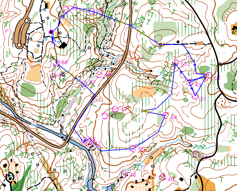
All in all, very good day. Huge thanks to Josef, Ken and Terese for organizing the event. The only bad news is that it looks like I will miss July 19 sprint. I wish it would be on Sunday next day, but, oh well.
Saturday, June 21, 2008
Orienteering over the phone
In the last few days I was merging two versions of the Umstead park map together. Tedious work, but I did learned quite a few additional OCAD tricks along the way. At the end I bumped into an area west of the Ready Creek Lake which had a lot of differences between two maps, but at the same time was away from majority of other "updated areas". I grew suspicious that this area was updated recently and therefore I should not touch it and asked Joseph about it. He suggested that I should go and look, so I decided to go there today.
Before I went into the park I found several "catchy" differences between two maps in that area and plotted them on one of the paper maps. My plan was to try to find these features or rather "find their absence", thus proving my suspicion. So yeah, I was fully prepared.
Right... When I arrived to the park I realized that forgot my paper map. Bummer. But I had a cell phone with me and so orienteering over the phone started :-)
I walked to the area, called Tanya and asked her to guide me though the features. It was fun. Tanya was giving me detailed description of the area and I was following her directions from feature to feature. We checked them all using this unusual method, it reminded me car rallies, where there are two people in one car: driver and navigator. Same kind of sport, I can see a good potential for a "2 people team" orienteering activity right there.
Wednesday, June 11, 2008
June 8 event in the Umstead Park (Report)
It was deadly hot on Sunday. Literally. 101 degrees, not a laughing matter. It looks like at least one runner fainted on the course and I saw many people in the state beyond normal exhaustion at the finish. It came to no surprise to me, as I was one of them.
We arrived about 11 AM (which was quite late) and it was already very hot. Tanya and Michael decided to go on Orange and I chose Green with a possible shortcut to Brown in mind. Jumping ahead, I did end up using this Brown shortcut and I am very grateful to Ken and Terese for designing the courses that way.
Anyway, I started up pretty good. I even ran for a while!
#1 - down to the creek, then noticed a re-entrant and walked up the hill.
#2 - compass bearing intentionally aiming slightly west of the control, so I knew where to go after I crossed the big creek.
Then the heat started to affect my thinking. I usually don't get tired so early on the course, but with 101 degrees in the air I started to loose concentration while looking for the control #3.
I went down to the creek to avoid an extra re-entrant, then went up using the right one, over the saddle and then I got lost for a few minutes. The forest was quite dense and somehow I ended up in a wrong re-entrant. I went down to the creek, checked my compass and realized that I am further north than I was supposed to be. Corrected the error and took the control #3.
At that point heat totally broke my defenses. I felt dizzy and nearly blacked out. Not a good feeling. I realized that I won't be able to keep running and thought about going back to the finish, but decided to slowly walk toward #4 and see how it goes. Since that point I did not run at all. Instead I walked while carefully choosing routes with less elevation, clear ground and more shade (yes, I noticed that I was indeed trying to avoid any kind of open space out there).
From #3 I went uphill, followed it to the trail bend and shot from there to #4.
#5 - compass bearing to the trail bend and over the hill.
I decided not to go straight to #6 as I was feeling very weak at that point, so I went along the creek and, when I gathered some strength, cut to the north till the control. And there was WATER! I spent 3-4 minutes there, resting and drinking. Then took compass bearing to #9 and with renewed strength set off for it.
Reached the road, noticed the curve and took another compass bearing. Reached the point where the control was supposed to be, but didn't see it. So I stood there in doubt. I could go further and double-check my position, but I was afraid to loose too much elevation by doing so. Fortunately, Josef appeared and pointed me to the control, as it turned out, I was in 15 yards from it.
Then I cut to the road, caught up with Josef and we walked together to #10. There was an urge to go and swim across the lake, but in the condition I was, I knew, I would definitely drown.
After #10 Josef went to finish his Red course, while I took full advantage of the Brown shortcut to the finish. But even with this shortcut it wasn't easy. While going uphill from #10 I had to rest three times before I reached the top. Michael told later on that he actually crawled there, well, I didn't, but I also came kind of close to it.
Then there was a slow walk to the finish. The whole Brown course took only 1 hour and 20 minutes for me, while I felt like I was in the wood for at least 2 hours more than that.
Sometime I think that all orienteerers are crazy...
Here is my route. Click on the image to enlarge. Blue - mostly running, yellow-brown - mostly walking, red dots - resting.
Sunday, June 8, 2008
June 8 event in the Umstead Park
Practically dead.
Ken and Terese saved my life with the Brown shortcut to the finish.
Will write a report tomorrow.
Monday, June 2, 2008
Highlighted map for the Umstead Park
Just a quick update on the latest activities. Joseph asked me to fix the Umstead map a bit, so it could be sold to the park visitors, so that's what I was doing during the last two weekends:
-- Moved the new trail behind the main shelter at Ready Creek entrance to the full map. I had this trails mapped in November last year, but it never got to the park map. Finally, it did :-)
-- Refreshed a bunch of small features in the same area (tables, benches etc.)
-- Mapped a few minor trails in the north part of the park
-- (And the hardest part!) Carefully highlighted all park trail and roads with pink color :-)
Sounds like a lot, but it wasn't much work really - just a few hours here and there. Now Joseph should be able to print the maps and I need to think about the next mapping project.
Monday, May 19, 2008
May 18 event in Schenck Forest
It was one of those days when calendar is too full of entries and every minute counts. Orienteering started at noon, Michael had a soccer game at 2 PM, then he and Tanya were going to the Vertical Edge club to do belaying on a birthday party while I had to be in the airport at 4 PM. So coming to the event we agreed not to spend more than an hour of our courses, which suited me well. Michael went on Yellow, Tanya on Brown and I had chosen Green.
The event was also a significant milestone for me, as the map used there was the one I was working on for the last 6 months. If you read this blog before, you probably saw my posts about mapping in Schenck Forest. So yes, it was all done specifically for this event.
Anyway, back to the course. Tanya and Michael started, but I was still looking at the course. Despite overabundance of trails and other features on the map, Ron was able to set pretty challenging green course, there were indeed several legs to think about carefully. Especially 6-7 and 14-16 ones.
I finally started and made my first mistake right there. I don't know what was it: over-confidence or something else, but I missed the correct re-entrant and overshoot good 60-70 yards until I realized what was going on. Returned back and actually met Tanya right at the control. I think I lost about 2 minutes there.
OK. Control #2 wasn't that hard, but I missed it too! I was running on the trail looking on my left for the re-entrant to appear and apparently missed it. Corrected myself at the small creek crossing, went over the creek, back and took the control. Not a big deal, but I also realized that despite me knowing the map so well, I still better be due-diligent about my orienteering and should treat the course seriously. There were no more mistakes after that (at least I think I have good excuses for other "curves").
In case of #3, #4 and #5 I knew exactly where the controls were going to be, so I was simply making some trade offs between the straight lines, terrain and forest density. Got a bit of a dog leg between #3 and #4. I didn't remember #6, but it was very easy to take from the trail. I met Tanya there again.
Then came the biggest leg on the course. I was already somewhat tired, so from that point on I was trying to avoid any extra elevation and hard forest. I crossed the creek and then avoided using the big re-entrant and went for the hill instead. The reason was that I remembered a lot of fallen trees in that re-entrant, so I took advantage of that knowledge. I ran up the hill, used one of the trails for a little bit, then took compass bearing to the left of the control and ran as straight as I could without paying attention to other trails. It worked out quite well, I hit the fence and went to the right to take the control.
#10 proved somewhat difficult for me to find. I was watching both terrain and trails while getting there but couldn't find the actual control quickly as it was very well hidden in the green.
Went to #11 using the creek as a handrail. Not sure it was the best choice, but at least I avoided climbing up a steep slope, which was a priority for me.
#12 was an easy find from the trail as well as #13. I used trails both times and I didn't go straight. I think it was a right decision. I wonder if anyone of you went straight there?
I knew where #14 was going to be, but nevertheless it took a while to get there. Underbrush was quite dense in that part of the forest. Then I decided to go straight #16. I took compass bearing, but it didn't help much. Underbrush was so thick that I lost a direction and exited it way to the west of the control. Quickly corrected myself, took #16, climbed out of the pit from the second attempt (brrr...) and ran to the finish.
Ended up spending 59.44 - perfect timing :-)
Michael already finished, but Tanya was still in the forest, so I had some time to talk to other runners. Josef, Ken and Terese were talking about possible set of sprint events for this summer. That would be awesome! If there are no issues with getting parks permissions let's do it!
Here is my route. Click on the image to enlarge.
Tuesday, May 6, 2008
Girl Scout Orienteering Event in Umstead
A few weeks ago Artem, Tanya and I volunteered to organize an orienteering event for Girl Scouts on May 4. As the date approached Artem designed a yellow course and coordinated all the logistics. There were really no work for me and Tanya until the actual event day.
On May 4th, we left the home early, picked up the maps from Joseph's porch and met Artem at the Girl Scout's camp parking lot in the North Umstead. Splitted the controls between three of us and set them quickly. Then Artem teached the class. It was hard. Imagine 19 nine years old girls and 4 parents, girls loosing attention all the time and parents trying to keep the discipline and at the same time listen to Artem. The hardest part was alignment of the map and compass - I don't think many students got it... At least not in the group I went with after the class.
Anyway, the class was over and off we went. I decided to go with the group #4, as a lady who chaperoned this group was really struggling with the concepts. She was visibly relieved when I told her that I'll stick with them :-)
Much to my surprise the girls got the idea pretty quick, but it was also clear that they enjoyed rocks and streams more than controls :-) Also half of the girls were always running ahead, while another half lagging behind along with the lady. Speaking about different temperaments!
After control #5 where we had to cross a creek the group started to fell apart. Some of the girls as well as the chaperon lady got tired, while others were trying to push ahead. The only uniting factor were occasional dogs on the trails. Every dog we met was thoroughly petted by the whole group. Girls, what can I say!
But, apparently, there were not enough dogs on the course... By the time we reached control #6, the tired part of the group became very tired and wanted to go back to the camp. It was a pity, as other girls wouldn't mind to finish the course. Fortunately, we also caught up with the group #3 and were able to re-group: girls who wanted to proceed went with that group and I walked the tired ones up to the hill and to the camp.
Artem and Tanya were already there and 45 minutes later everybody has finished. It looks like they liked the activity. And a tortoise they found on the course made the day!
Who knows, it might be the same one I saw sitting on top of the ribbon a month ago during the April event.
Sunday, April 20, 2008
April 20 training event in South Umstead (Whispering Pines)
I don't remember being so tired on an orienteering event. At least not in the last few years... Artem set up very very physically challenging event. Part of my fatigue was because of the CT scan I took on Friday, part because of the route I took, but most of it was indeed attributed to the way controls were set and scored as well as to the small time limit. Well, I actually liked 1 hour limit, as it is exactly how long my knee seems to be holding up, but I was (like everybody else) late on the finish and therefore pushed myself too much at the end.
But let's start from the beginning. We (Michael, Tanya and I) arrived quite early, but there were already people starting up. Artem gave us the maps (short ones) and it was immediately obvious that it was going to be hard. Michael walked us to the start and all the way there I was trying to make up my mind on which route to take. It was quite clear that I wasn't going to take them all in one hour, so I had to decide which 30 pointers to target. There were indeed a lot of choices. Tanya had started and Michael followed her shortly afterwards and I was still standing at the start control thinking. Finally, I decided to concentrate on the south east part of the map. Jumping ahead I think I made a strategical mistake there: north area with T30 and A30 would have probably be a bit easier for me, especially physically. But at the same time I almost avoided using roads (which I guess is a plus... maybe...).
So, my plan was: X5, J5, G10, W30, V15, M30, E10, O10 and maybe also A30 (plus Q5 on the way back).
X5 was easy, though it was the most tricky one in terms of "poisonous controls". Small re-entrant and gully looked very similar, but still it wasn't hard to decide which one is the northern one there.
J5 was again an easy find if not counting climbing over a lot of fallen trees in the greenish re-entrant and gully over there.
Then I ran south to the road and went of the map... Yes, basic mistake like that...I saw the trail emerging in north-east direction on the map and I saw a trail sign down the road. I made an assumption that the sign was for that trail and shoot for it instead of cutting through the woods. I found a trail there, took it and later on discovered that it was going south east instead of north east. I have no idea where I missed the trail split, but I did miss it and took southern branch, thus going further and further off the map... When I realized what was going on I decided against running back, as I was sure about hitting the road soon (the one that then would cross the power line). It was a correct decision, at the end I indeed hit that road and reached the power line in the very south east corner of the map. It turned out that I didn't loose a lot of time on this run around off the map. The control wasn't hard to find from that intersection, but I suspect that it wasn't set correctly. I went down the re-entrant and started to count side re-entrants on the left. Much to my surprise there was a control in the very first one. I decided that it was a "poisonous" one and went further. Reached the next re-entrant, noticed creeks crossing and re-entrant on the right side, but there was no control... Looked around, looked some more - still no control. Then I suspected that the control wasn't set right, returned back, found yet another "poisonous" one, took the one at the bottom and went off. I might be wrong there, of course. Artem was going to check this control later on to make sure.
Then I went for V15. It was stupid. I was already short on time and should have abandoned it and go for M30 using low elevation route by the river. But I went up to the power line, went up hill, lost my breath and there realized that there was no way I could take both V15 and M30 and still be on time. I wish I wouldn't use this power line at all, I wish I would take M30 from the river... But I used power line, made all those huge ups and downs and completely exhausted myself.
All right, I took M30 and it was time to go back to the finish. Used power line to reach the river, crossed it (almost waist deep) and took E10. Then went by X5 again and to the road. Crossed one bridge, then another and my time was up then.
It took me 8 minutes and the rest of my strength to go by the lake shore and Q5. I was walking most of the time there, feeling quite miserable.
Finished with 95 points (-35 for being late) with the final score of 60. Lol - I could have simply take two 3o pointers to get these points. At the finish I found a lot of runners feeling quite the same :-)
Tanya and Michael ran their courses smarter than me. Tanya took X5, O10, A30 and Q5 and was only 2 minutes late with 44 points. Michael took both A30 and T30 (plus X5, O10 and Q5) and ran all the way back very quickly using the road, so he ended up just a little bit late and with 50 points.
All in all - good but very tough event. Very unlike to our ordinary advanced courses.
Here is my route (except for the "out of the map portion"). Click on the image to enlarge. Blue - mostly running, yellow-brown - mostly walking.
Friday, April 18, 2008
Schenck Forest Map
Transferred my field notes to the OCAD file of the Schenck Forest map today and sent it to Joseph. I am done with it. I know that the refresh is not perfect, but I think this is the best I can produce at this moment. Hopefully, the refreshed map can be used during the May 18th event.
One snippet of the north-east part of the map. This is where I got lost a year ago:
And now, this is the same area after the refresh. I do feel better now about me being lost there last year :-) Quite different, isn't it?
Sunday, April 13, 2008
April 13 event in the North Umstead Park.
Maybe we should skip "13"s in the future events calendar after all... There was a serious injury today on the red course. Nadya had a head injury, lost a lot of blood and ended up in the hospital with 16 stitches and concussion. She called me this evening and seemed to be recovering fine, but it was a scare. She was also fortunate that Charles was running right by soon after she got hurt. But in the future, please, never ever go on the course without a whistle.
The day started very well though. Perfect weather for orienteering. Tanya and Michael went to Gary's advanced orienteering class (and, by the way, had a great and useful lesson), while I set 20 or so white, yellow and orange controls (2 advanced ones as well). I funny thing happened to me at #43. This advanced control was close to the road, so a week ago I put the ribbon there literally on the ground. Today I was there looking for the ribbon and couldn't find it. I knew it was supposed to be there, so I looked closely and then I saw a turtle sitting right on top of the ribbon and thus hiding it :-) I hanged the control on top and let it be. I wonder if anyone saw the turtle later on at this control.
At 11 AM everything was ready except for the printer... It wouldn't work. No matter what I was doing it wouldn't print. It messed up the event a bit, as Tanya had to explain to everyone that the printer was out, but that download box was still needed (thanks to Memund and Ken for telling us about it). We also tried to write down start/finish time, but I am afraid didn't do it for everyone. I really hope that the problem was with the printer and not the download box, so the results will be there.
Anyway, Josef was the first to start and the event went on. We had a lot of reds and only a few yellows. Kind of strange distribution - for some reason not many kids were in the forest today. It looked like that advanced runners were pleased with the courses: I set controls very low and sometime even hidden, so they could be found only if you find the exact feature - and everyone seemed to like the challenge.
I got thanks for White and Yellow too. The only problematic course was Orange: a few long times and DNFs there and one complain about a control being set incorrectly (in wrong gully). During the controls pick up I went and double-checked that control (#51, #6 on the course), tried it from 4 different attack points and I can confirm that the control was set 100% correctly. Below is the picture with the attack points (from top to bottom):
- leave the trail, notice a dry ditch and a gully, then move south-east to the right gully
- notice a stone wall (bridge) on the creek and take a bearing to the gully
- notice a stony ground by the creek and take a bearing to the gully
- start from the tooth shaped big rocks on the other side of the creek, take a bearing to the big gully and then go north to the right one
There were a few late finishers, but everyone got back. Artem and Bill helped with controls pick-up, Michael took a lot of white and yellow ones and Tanya and I a few others. All in all we were done by 4.30 - rather quick!
Huge thanks to everyone who helped:
- Bill, Artem, Joseph and Ruth with controls pick-up
- Ken with the class (Michel and Gary also offered to teach the class, but Ken was the first)
- Joseph and Ruth with course consulting
- Ken and Joseph with results
Cheers!
P.S. One of the reasons we were so quick with the controls pick-up was that Joseph and Ruth asked us to leave Brown and Green course in the park, so they would run on Monday - so we did. I moved the last control down a bit (to hide it) and inadvertently added one Orange control to these left over Brown and Green courses. It's going to be harder now :-)
Saturday, April 12, 2008
Finishing field work in Schenck Forest
I think I am done with the field work there. It's not 100%, but I think the refresh coverage is decent enough and it is the best I can do for the May event.
Spent 4 hours in the eastern part of the Schenck Forest today despite two thunderstorms. Got soaked twice. I can tell you, it is really hard to map while holding the map holder upside down all the time :)
Spent most of the time in the north-east part, it was indeed very outdated. No wonder I got lost there during the last year's event - the map in that area was plain wrong! I mean it, even terrain has changed. None of the trails was accurate and all yellow areas either disappeared or became dark green.
Didn't refresh the hill on the south-east end of the park, as there was a tent set by homeless people. I didn't dare to disturb them. I don't remember this tent from the last year, it must be new. What's up with all these homeless people's settlements in Umstead and Schenck? It's kind of sad and disturbing.
Friday, April 11, 2008
Placing advanced controls
Tanya and I placed 17 advanced controls today. Initially I though we would do it on Saturday, but Tanya has to be in the theater for the 2 PM show that day, so I took the day off and we set the advanced controls today.
What can I say? It was hot! 80 degrees - felt like summer already. Fortunately, Sunday is going to be cooler.
We split the controls between two of us, so it was much faster than setting ribbons - it took only about 1.5-2 hours to place them all.
P.S. In the middle of it I got a call on my cell from a customer who had some questions about the code I delivered last week. For once I felt like a very mobile employee: walking in the forest, looking for a ribbon and at the same time debugging code with a customer on the phone :-)
Thursday, April 10, 2008
April 13th event start location
Here is where the start will be. Small picnic shelter by the main parking lot.
Sunday, April 6, 2008
My first Radio-O and remaining ribbons
Big day today.
Two weeks ago Nadya and Charles kindly agreed to introduce me, Tanya and Michael to Radio Orienteering. I've always wanted to try it and, finally, my dream came true :-) Last weekend the weather wasn't nice, so Nadya and Charles decided to move the training to this Sunday and it worked out nicely.
Tanya couldn't come, because of long hours she had to put in the theater this weekend, but Michael agreed to accompany me. Nadya also invited Larisa, so there were five of us (as far as I understood we were the second biggest Radio-O club in the US at that moment :-) ). I was a bit concerned about complexity of the equipment and rules at the beginning, but it turned out to be much simpler than I thought. Nadya explained the essentials in 10 minutes and off we went looking for the transmitters! And you know what? It was fun!
I am surprised so few people participate in this sport. It not only requires regular orienteering skills, but also gives you a mathematical challenge! You can view every course as a geometrical problem with several unknowns which you gradually resolve while running through the forest! Speaking about a sport for thinking runners!
Anyway, I think both me and Michael are hooked up now and Tanya will definitely try it too. We'll see how often such trainings can be organized, but I hope we can do it at least 1-2 times a month.
After the Radio-O I brought Michael home, drove Tanya to the theater and returned back to the Umstead Park to finish the ribbons setting. No rain today and less distance, so I was done in 2 hours. Interestingly, I had to move 4 white and yellow controls after visiting the planned spots. Things like overflown creeks on White course and freshly fallen trees caused the adjustments. Yet another reason to check all White and Yellow controls BEFORE the map is finalized!
But the map is finalized now and the only remaining field work will come on Friday when Tanya and I plan to set the advanced controls (and of course during the event day).
I guess, that concludes this day report :-) Indeed, an eventful day.
Saturday, April 5, 2008
Rain and Ribbons
The park rangers asked us to modify the courses in order to avoid two camp areas, so as a result advanced courses got two easy controls instead of one of the difficult ones. Oh, well... Nothing I can do about it, just don't get surprised when you see those two controls and road between them...
Anyway, now the courses are final and I went into the park to set ribbons today. Tanya couldn't go with me as she had to spend the whole day at the Raleigh Little Theater (preparation for Peter Pan just got started and Tanya is in the deck crew). Jumping ahead, I am glad, that I put my lenses on instead of the glasses! Otherwise, I wouldn't be able to set an many ribbons as I did today.
I started from the Visitors Center and made a big circle (8-9KM) visiting almost all Orange, Brown, Green and Red controls. Spent a lot of time (4 hours), mostly because of the difficulties with dry ditches. Maybe I am imagining things, but it looks like the north part of the park is not mapped as accurately as the south one. So many dry ditches not shown on the map - in some cases it gets really confusing. I spent about 30 minutes on one of the controls (east of the Visitor Center), trying to pin point the exact location of a dry ditch I was looking for. Ouch. Hopefully, I selected the right one (took several different bearings to check), but I am still not as confident there as with other controls. There was also a place where I found two cliffs instead of one (some very curious terrain there). Finally, the power line should have been yellow instead of dark green (not a big deal, as the courses go across).
The rain started soon after I started, but it wasn't cold and I had lenses on, so I decided to keep on going and finished the circle. Ended up totally soaked, but not cold. All in all it was a good walk - and most of the work was done.
There are 4 ribbons remaining for tomorrow, plus while and yellow course to visit. Maybe Tanya or Michael will join me for a walk this time.
Sunday, March 30, 2008
Courses for the April 13 event in North Umstead
Two days ago I received a confirmation from the park management that Umstead North is OK for the April 13 event. Moreover, they told us that we will be able to use a small shelter there for registration and start, which is very nice.
I designed the courses yesterday and after a few minor corrections from Tanya and Joseph, the courses went to the park management for review. If everything goes smoothly here are the parameters:
- White 1.8 KM, 9 controls
- Yellow 2.8 KM, 11 controls
- Orange 3.5 KM, 12 controls
- Brown 4.4 KM 12 controls
- Green 5.5 KM 14 controls
- Red 7.3 KM, 17 controls
Runners will be able to choose between Brown, Green and Red around the middle of the course.
Sunday, March 23, 2008
Sprints at Crab Tree Lake
In short summary: excellent courses, great day, new forest, it is so nice to be able to run sprints from time to time! No long legs :-)
Tanya and I arrived at 11.30 hoping to start earlier as Tanya was required at Raleigh Little Theater for 3 PM play (meaning she had to be there by 2 PM). By the way, if you haven't been in this theater before, I would highly recommend it - the plays they stage there are always very good. It is cheap too, comparing to big ticket arenas and stages.
Fortunately for us, Terese, Ken and Josef were already there and ready. So we went right ahead. Tanya took the east course while I started the west one. How did it go? I think pretty good for myself, though, I made a few mistakes and looking back could probably have saved about 60-90 seconds. It's funny how I consider 15 seconds delays to be mistakes on this course while on regular courses 2-3 minutes long walks are totally acceptable. Sprint - what can I say!
One important decision I made before the start was to ignore the trails on both courses. Similar to Schenck Forest bike trails, trails at the Crab Tree Lake park are also multiple, confusing and NOT straight. So during the courses I was ignoring the trails as much as I could and used compass and elevation contours instead.
West Course
I was totally alone out there.
1. #51 (1:15). Pretty much a straight shot, I used the second parking lot as an attack point.
2. #52 (1:47). Again straight run, counting re-entrances (one, two, in the third). I liked how I could run straight there and at the same time cross re-entrances in their top parts. This way no elevation is lost, which is very important when physical condition is not that good.
3. #53 (1:25). Compass bearing and counting re-entrances, easy.
4. #54 (2:00). Minor mistake, as I went down the hill a little bit early. Lost 5 seconds :-)
5. #55 (1:59). Initially I was going to run along the creek, but crossing it by the control wasn't looking very inviting to me, so I took advantage of the trail there. Probably, not the optimal way to go... Lost another 5 seconds, maybe.
6. #56 (0:50). Compass bearing over the hill. Ideal.
7. #57 (0:39). Hmm, stepped up and looked around :-)
8. #58 (2:46). Got confused by the terrain and lost time (30 seconds). If you look at the #58 from #57 it appears that #58 is on a hill, while it is NOT! Looking from other side, you can see that it is in a re-entrant. I think the map is really confusing there.
9. #59 (2:58). Lost another 30 seconds. Don't have an excuse this time. My tired brains decided that the control must be invisible from the trail (LOL), so I went into the forest 30 yards before the control and had to navigate through underbrush and fallen trees only to return back to the trail with the control right by. While I was beating bushes I also saw someone running there, got surprised as I was supposed to be the only one on the course, but then saw two beautiful deers running toward the control. I wish I could jump over the trees like they did...
10. #60 (1:23). Trail.
11. #61 (1:15). Road and parking lot. Thankfully, no thinking was required on the last few legs.
And finish in 0:43 for a total of 19:00.
(click on the picture to see it all)
After half an hour of rest, I was ready for the second course. I thought it will be longer, but I was proved to be wrong, the East course was easier for me with just one 30 seconds mistake.
East Course
1. #62 (1:03). Trail and parking lot.
2. #63 (1:49). Compass bearing and trail.
3. #64 (1:50). Again compass bearing, I was also looking at the shape of the hill, which helped.
4. #65 (0:56) Compass bearing, keeping an eye on my elevation.
5. #66 (1:20) The same. Both controls were visible from far away.
6. #67 (1:01) Took advantage of the western trail, again, avoiding any extra steps up.
7. #68 (1:51) Compass bearing, re-entrance, hill, control.
8. #69 (1:07) Went down and used the trail.
9. #70 (1:00) Along the creek, nothing to add.
10. #40 (1:27) Compass bearing, over the tip of the hill, into re-entrant and up another hill. Was kind of slow coming up there...
11. #41 (2.39) My 30 seconds mistake... As usual, my tired brains decided that I hadn't had enough distance, so they decided to take control #1 instead #11. Yeah... I recognized the error when I hit the road and "corrected" it by running toward the NUMBER 11 on the map instead of the control #11... Well, I successfully took the NUMBER 11 and only then understood that I am supposed to chase CIRCLES, not NUMBERS!
And then finish in 0:29 for a total time of 16:32.
All in all I was pretty happy with the results.
I drove Tanya to the theater and there we remembered that we forgot our jackets in the park, so instead of going home, I went back to the park and helped with the controls pick up. It was a pleasure to sit at the finish and chat with fellow runners. I should try and stay after the finish more often.
(click on the picture to see it all)
Thursday, March 20, 2008
Biking Trails in Schenck Forest. Comparison
Joseph sent me a picture of the north-west part of Schenck Forest mapped by Josef Trzicky, so I could compare how I mapped it with Josef's version. While, it is a pity, that we did double work there, I am still glad, because now I can see what I missed and where I should improve.
The trails themselves turned out to be mapped almost identical. The only big difference between two versions is shown on the image below. I will come there next time and doublecheck. But the amount of small details (trees, knolls etc.) and additional corrections Josef did is amazing. I do have a long way to go.
(click on the picture to see it all)
Monday, March 17, 2008
Idea for a new Training Event format
I have this crazy idea for making a "treasure hunt" Score-O event. I think it would be very fun to do, but, please, comment. Maybe it is too crazy :)
Here is the idea.
1. The event is a Score-O, meaning there is a time limit, penalties for being late and points are rewarded for each control taken.
2. But only 5 controls are shown on the map! And there are 4 long legs between these 5 controls. (see the picture 1 below)
3. All other controls are set along these long legs, but not quite!
4. There are exactly five extra controls on every leg (see the picture 2 below), so if a runner found all five, he/she would know that this leg is fully taken.
5. I think that mass start should work best for such event, but it is OK to start separately as well.
During such event runners will have to make guesses where those extra controls are, look for other runners around, remember where they are at any given moment and manage their time closely. Plus it will be fun to see the full map at the finish and see where were all hidden controls.
P.S. If 4 legs are too much, it can be scaled down to 4 main controls and 3 long legs.
What do you think?
Picture 1. Every runner gets this map (click to enlarge).
Picture 2. Map with hidden controls, shown at the finish.
Sunday, March 16, 2008
Thank you for reading!
One thing I forgot to mention in my report is that several people approached me during the event saying that they saw and liked this blog. It was very encouraging and I thank you for reading it! I'll try to keep it up.
March 16 event at Umstead Park, Camp Lapihio
It was a great day for orienteering! Not too cold, not too hot, no rain and clear forest!
But, unfortunately for me, the course (green) was set in a way I always struggle with. And I struggled again. One distinct weakness in my orienteering is inability to perform good on courses with multiple consecutive long legs. I can handle two long legs in a row, but the third one usually kills me. I am getting very tired and starting to make poor decisions. And because the legs are long, every mistake is very costly. Long legs do not allow me to make corrections quickly and often lead to a lot of extra time and distance.
So, yeah. Today's green course had five (!!!) consecutive long legs, starting from the second control.
OK, here is how it went. The first control (#71) was easy, though I made an extra curve (don't ask me why, I have no idea how it happened). Then long legs started. I took the second control (#72) OK by going south to the trail, following the trail and making another shortcut to the south from there. But I felt "the long leg effect" even then: when I came to the area where the control was I didn't notice it and went west looking for it, while it was literally a few meters away from me. Such things happen to me quite often when I am tired, I wasn't very surprised.
There was another plausible route to that control: down the creek and up the river before making for the trail. But I remembered this creek from the training event and there were some nasty fallen trees, so I went other way this time. I think both ways are fine.
The next one (#74) I took nicely, avoiding a bunch of deep re-entrances by using the paved road. Then came #40. After a quick look at the map I immediately decided that I shouldn't go straight and need to use the paved road again. Though it was definitely longer, by taking the road I would stay almost on the same elevation. Plus it was the third long leg and I wanted to do it using a simple "non-thinking" way. The control would have to be further south to make me run straight to it. Anyway, my strategy worked, the result wasn't as clean as it could be, but it was OK. While running on the paved road I also made on the spur of the moment decision to use the power line shortcut, which turned out to be a good one.
Initially I wasn't going to use the power line and let me tell you why. The reason is that I am afraid of running there. Actually, I think, it is plain dangerous. A few years ago they cut bushes under the power line and left 10-30 centimeter long stumps over there. These bush stumps are low and sharp. It is OK to walk there, but if a runner trips and falls a serious injury may occur with a big probability. Seriously, I think, that we should take this into account while setting courses and make sure the controls are set in a way that there is no incentive whatsoever to use the power line in this area of the park.
But today, I did use the power line, it looked a bit clearer from the road than I remembered. But still it was very uncomfortable to run there, so I entered the forest earlier than I initially wanted.
After three long legs I arrived on my forth control (#40) totally exhausted and then made my biggest mistake of the day. Actually it was a double mistake:
-- firstly I took a wrong compass bearing leaving the control and ended up hitting the road further east that I thought
-- secondly I didn't correct my first mistake by running till the road curve
As a result I entered the forest two (!!!) re-entrances off. Ouch. I think I even went off the map for a while... I recognized that I was by the wrong re-entrant quite soon, but I couldn't imagine that I was two re-entrants off, not just one. So I went north one step and was still in the wrong area. So I was standing there, thinking where am I for a minute or two and decided that I just don't know. I ran south-west, hit the road again and this time took the control (#43) properly.
Needless to say, these extra legs didn't give me additional strength. The rest of the course I was half walking. But at the same time the course from that point on became a kind of "survival" adventure: two river crossings and a mountain...
Controls #46, 47 and 48 were very easy, but to get there... I went down to the river and there were no trees across it. I called out a hiker from the other shore if he saw any trees, he said no, so I crossed the river right there. It was knee deep. Then there was the mountain. I should have probably had strength left to run up the slope, but I hadn't and ended up slooowly walking up. I met Ruth at the control (#46). Nothing much to say about #47 - just two re-entrances away, easy find. #48 was also easy - hit the trail north-north-west, followed the trail a bit and then made a shortcut.
And finally, another river crossing to get to the finish! Awesome :-)
Here is my route (click on the image to see the full course). Blue are legs where I mostly ran, Greenish are legs where I mostly walked.
Thursday, March 13, 2008
My first orienteering event
I was 17 when my older brother introduced me to orienteering. But I wouldn't say it was a gentle and smooth introduction. Far from it. But, hey, that's what older brothers for, right? Here is the story.
In 1990 I finished high school and got accepted into the Belorussian State University. One of the mandatory courses there was 'normal' physical education. Gym, swimming pool etc. Boring stuff. So, many students were choosing to participate in specific athlete programs instead. Orienteering was one of them, my brother was already a member and, naturally, he advised me to join. I signed up, thinking that I'll get some amount of initial training, only to discover that the whole orienteering team consisted of 5 students and our first event of the year (meaning educational year) was in two days. Moreover this event was the championship between Belorussian colleges and all 5 members would have to compete. Ouch... So much for training.
The course had 15 controls and 12 kilometers with 3 hours time limit. Forest in Belarus is easier than in North Carolina, but 12 kilometers is still kind of blueish. My brother gave me a compass and explained the map ("white" is forest, "green" is more forest, if you see a control you'll recognize it - this kind of teaching). I was rightfully confused and asked how am I supposed to find all those 15 controls. Other four team members discussed it and came up with seemingly "perfect" and "sure" strategy:
I was supposed to find the first control and wait there for other runners (who would start after me). As soon as I see a runner in some kind of "cool" orienteering gear (which meant the runner is a "pro") I was supposed to follow this runner till the finish. That simple.
Fine. After 10 minutes of initial confusion I managed to find the first control and set put. Two minutes passed and here he was - the perfect target! "Cool" orienteering gear, running and jumping (later on I learned that he was indeed a high ranked runner). He took the control and I followed him. We took the second control together, then the third one. For some reason the runner wasn't happy about me following him. No, he wasn't. He was looking back frequently, cursing and increasing pace from time to time. But I was young and persistent. After the third control the runner got very agitated because of my presence, literally, he looked at me more often than he looked at the map. And we kept running. Soon we reached the next control. My involuntary guide punched his score card and next thing I knew he was shouting in anger and anguish. Apparently he was so concerned with getting rid of me, that he accidentally ran back to control #2 instead of #4... Oops. And not only he lost time, he also punched his card there, which could cause a disqualification. Cursing and shouting he ran away and I didn't dare to pursue him anymore.
The rest of the course I took alone and finished after spending 3 hours and 5 minutes in the forest. The judges at the finish were so glad to see me (as I was the last in), that they waived these extra 5 minutes and my result got counted for the team.
As you can imagine, I got hooked up to orienteering right there and right then.
P.S. And don't ask me how my legs felt in the following two days :-)
Subscribe to:
Posts (Atom)
