I don't remember being so tired on an orienteering event. At least not in the last few years... Artem set up very very physically challenging event. Part of my fatigue was because of the CT scan I took on Friday, part because of the route I took, but most of it was indeed attributed to the way controls were set and scored as well as to the small time limit. Well, I actually liked 1 hour limit, as it is exactly how long my knee seems to be holding up, but I was (like everybody else) late on the finish and therefore pushed myself too much at the end.
But let's start from the beginning. We (Michael, Tanya and I) arrived quite early, but there were already people starting up. Artem gave us the maps (short ones) and it was immediately obvious that it was going to be hard. Michael walked us to the start and all the way there I was trying to make up my mind on which route to take. It was quite clear that I wasn't going to take them all in one hour, so I had to decide which 30 pointers to target. There were indeed a lot of choices. Tanya had started and Michael followed her shortly afterwards and I was still standing at the start control thinking. Finally, I decided to concentrate on the south east part of the map. Jumping ahead I think I made a strategical mistake there: north area with T30 and A30 would have probably be a bit easier for me, especially physically. But at the same time I almost avoided using roads (which I guess is a plus... maybe...).
So, my plan was: X5, J5, G10, W30, V15, M30, E10, O10 and maybe also A30 (plus Q5 on the way back).
X5 was easy, though it was the most tricky one in terms of "poisonous controls". Small re-entrant and gully looked very similar, but still it wasn't hard to decide which one is the northern one there.
J5 was again an easy find if not counting climbing over a lot of fallen trees in the greenish re-entrant and gully over there.
Then I ran south to the road and went of the map... Yes, basic mistake like that...I saw the trail emerging in north-east direction on the map and I saw a trail sign down the road. I made an assumption that the sign was for that trail and shoot for it instead of cutting through the woods. I found a trail there, took it and later on discovered that it was going south east instead of north east. I have no idea where I missed the trail split, but I did miss it and took southern branch, thus going further and further off the map... When I realized what was going on I decided against running back, as I was sure about hitting the road soon (the one that then would cross the power line). It was a correct decision, at the end I indeed hit that road and reached the power line in the very south east corner of the map. It turned out that I didn't loose a lot of time on this run around off the map. The control wasn't hard to find from that intersection, but I suspect that it wasn't set correctly. I went down the re-entrant and started to count side re-entrants on the left. Much to my surprise there was a control in the very first one. I decided that it was a "poisonous" one and went further. Reached the next re-entrant, noticed creeks crossing and re-entrant on the right side, but there was no control... Looked around, looked some more - still no control. Then I suspected that the control wasn't set right, returned back, found yet another "poisonous" one, took the one at the bottom and went off. I might be wrong there, of course. Artem was going to check this control later on to make sure.
Then I went for V15. It was stupid. I was already short on time and should have abandoned it and go for M30 using low elevation route by the river. But I went up to the power line, went up hill, lost my breath and there realized that there was no way I could take both V15 and M30 and still be on time. I wish I wouldn't use this power line at all, I wish I would take M30 from the river... But I used power line, made all those huge ups and downs and completely exhausted myself.
All right, I took M30 and it was time to go back to the finish. Used power line to reach the river, crossed it (almost waist deep) and took E10. Then went by X5 again and to the road. Crossed one bridge, then another and my time was up then.
It took me 8 minutes and the rest of my strength to go by the lake shore and Q5. I was walking most of the time there, feeling quite miserable.
Finished with 95 points (-35 for being late) with the final score of 60. Lol - I could have simply take two 3o pointers to get these points. At the finish I found a lot of runners feeling quite the same :-)
Tanya and Michael ran their courses smarter than me. Tanya took X5, O10, A30 and Q5 and was only 2 minutes late with 44 points. Michael took both A30 and T30 (plus X5, O10 and Q5) and ran all the way back very quickly using the road, so he ended up just a little bit late and with 50 points.
All in all - good but very tough event. Very unlike to our ordinary advanced courses.
Here is my route (except for the "out of the map portion"). Click on the image to enlarge. Blue - mostly running, yellow-brown - mostly walking.
Sunday, April 20, 2008
April 20 training event in South Umstead (Whispering Pines)
Friday, April 18, 2008
Schenck Forest Map
Transferred my field notes to the OCAD file of the Schenck Forest map today and sent it to Joseph. I am done with it. I know that the refresh is not perfect, but I think this is the best I can produce at this moment. Hopefully, the refreshed map can be used during the May 18th event.
One snippet of the north-east part of the map. This is where I got lost a year ago: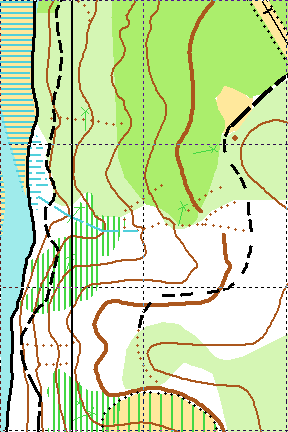
And now, this is the same area after the refresh. I do feel better now about me being lost there last year :-) Quite different, isn't it?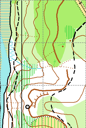
Sunday, April 13, 2008
April 13 event in the North Umstead Park.
Maybe we should skip "13"s in the future events calendar after all... There was a serious injury today on the red course. Nadya had a head injury, lost a lot of blood and ended up in the hospital with 16 stitches and concussion. She called me this evening and seemed to be recovering fine, but it was a scare. She was also fortunate that Charles was running right by soon after she got hurt. But in the future, please, never ever go on the course without a whistle.
The day started very well though. Perfect weather for orienteering. Tanya and Michael went to Gary's advanced orienteering class (and, by the way, had a great and useful lesson), while I set 20 or so white, yellow and orange controls (2 advanced ones as well). I funny thing happened to me at #43. This advanced control was close to the road, so a week ago I put the ribbon there literally on the ground. Today I was there looking for the ribbon and couldn't find it. I knew it was supposed to be there, so I looked closely and then I saw a turtle sitting right on top of the ribbon and thus hiding it :-) I hanged the control on top and let it be. I wonder if anyone saw the turtle later on at this control.
At 11 AM everything was ready except for the printer... It wouldn't work. No matter what I was doing it wouldn't print. It messed up the event a bit, as Tanya had to explain to everyone that the printer was out, but that download box was still needed (thanks to Memund and Ken for telling us about it). We also tried to write down start/finish time, but I am afraid didn't do it for everyone. I really hope that the problem was with the printer and not the download box, so the results will be there.
Anyway, Josef was the first to start and the event went on. We had a lot of reds and only a few yellows. Kind of strange distribution - for some reason not many kids were in the forest today. It looked like that advanced runners were pleased with the courses: I set controls very low and sometime even hidden, so they could be found only if you find the exact feature - and everyone seemed to like the challenge.
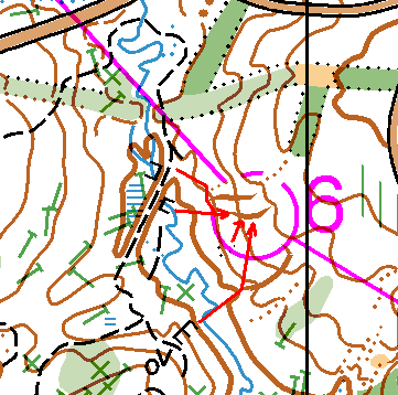
I got thanks for White and Yellow too. The only problematic course was Orange: a few long times and DNFs there and one complain about a control being set incorrectly (in wrong gully). During the controls pick up I went and double-checked that control (#51, #6 on the course), tried it from 4 different attack points and I can confirm that the control was set 100% correctly. Below is the picture with the attack points (from top to bottom):
- leave the trail, notice a dry ditch and a gully, then move south-east to the right gully
- notice a stone wall (bridge) on the creek and take a bearing to the gully
- notice a stony ground by the creek and take a bearing to the gully
- start from the tooth shaped big rocks on the other side of the creek, take a bearing to the big gully and then go north to the right one
There were a few late finishers, but everyone got back. Artem and Bill helped with controls pick-up, Michael took a lot of white and yellow ones and Tanya and I a few others. All in all we were done by 4.30 - rather quick!
Huge thanks to everyone who helped:
- Bill, Artem, Joseph and Ruth with controls pick-up
- Ken with the class (Michel and Gary also offered to teach the class, but Ken was the first)
- Joseph and Ruth with course consulting
- Ken and Joseph with results
Cheers!
P.S. One of the reasons we were so quick with the controls pick-up was that Joseph and Ruth asked us to leave Brown and Green course in the park, so they would run on Monday - so we did. I moved the last control down a bit (to hide it) and inadvertently added one Orange control to these left over Brown and Green courses. It's going to be harder now :-)
Saturday, April 12, 2008
Finishing field work in Schenck Forest
I think I am done with the field work there. It's not 100%, but I think the refresh coverage is decent enough and it is the best I can do for the May event.
Spent 4 hours in the eastern part of the Schenck Forest today despite two thunderstorms. Got soaked twice. I can tell you, it is really hard to map while holding the map holder upside down all the time :)
Spent most of the time in the north-east part, it was indeed very outdated. No wonder I got lost there during the last year's event - the map in that area was plain wrong! I mean it, even terrain has changed. None of the trails was accurate and all yellow areas either disappeared or became dark green.
Didn't refresh the hill on the south-east end of the park, as there was a tent set by homeless people. I didn't dare to disturb them. I don't remember this tent from the last year, it must be new. What's up with all these homeless people's settlements in Umstead and Schenck? It's kind of sad and disturbing.
Friday, April 11, 2008
Placing advanced controls
Tanya and I placed 17 advanced controls today. Initially I though we would do it on Saturday, but Tanya has to be in the theater for the 2 PM show that day, so I took the day off and we set the advanced controls today.
What can I say? It was hot! 80 degrees - felt like summer already. Fortunately, Sunday is going to be cooler.
We split the controls between two of us, so it was much faster than setting ribbons - it took only about 1.5-2 hours to place them all.
P.S. In the middle of it I got a call on my cell from a customer who had some questions about the code I delivered last week. For once I felt like a very mobile employee: walking in the forest, looking for a ribbon and at the same time debugging code with a customer on the phone :-)
Thursday, April 10, 2008
April 13th event start location
Here is where the start will be. Small picnic shelter by the main parking lot.
Sunday, April 6, 2008
My first Radio-O and remaining ribbons
Big day today.
Two weeks ago Nadya and Charles kindly agreed to introduce me, Tanya and Michael to Radio Orienteering. I've always wanted to try it and, finally, my dream came true :-) Last weekend the weather wasn't nice, so Nadya and Charles decided to move the training to this Sunday and it worked out nicely.
Tanya couldn't come, because of long hours she had to put in the theater this weekend, but Michael agreed to accompany me. Nadya also invited Larisa, so there were five of us (as far as I understood we were the second biggest Radio-O club in the US at that moment :-) ). I was a bit concerned about complexity of the equipment and rules at the beginning, but it turned out to be much simpler than I thought. Nadya explained the essentials in 10 minutes and off we went looking for the transmitters! And you know what? It was fun!
I am surprised so few people participate in this sport. It not only requires regular orienteering skills, but also gives you a mathematical challenge! You can view every course as a geometrical problem with several unknowns which you gradually resolve while running through the forest! Speaking about a sport for thinking runners!
Anyway, I think both me and Michael are hooked up now and Tanya will definitely try it too. We'll see how often such trainings can be organized, but I hope we can do it at least 1-2 times a month.
After the Radio-O I brought Michael home, drove Tanya to the theater and returned back to the Umstead Park to finish the ribbons setting. No rain today and less distance, so I was done in 2 hours. Interestingly, I had to move 4 white and yellow controls after visiting the planned spots. Things like overflown creeks on White course and freshly fallen trees caused the adjustments. Yet another reason to check all White and Yellow controls BEFORE the map is finalized!
But the map is finalized now and the only remaining field work will come on Friday when Tanya and I plan to set the advanced controls (and of course during the event day).
I guess, that concludes this day report :-) Indeed, an eventful day.
Saturday, April 5, 2008
Rain and Ribbons
The park rangers asked us to modify the courses in order to avoid two camp areas, so as a result advanced courses got two easy controls instead of one of the difficult ones. Oh, well... Nothing I can do about it, just don't get surprised when you see those two controls and road between them...
Anyway, now the courses are final and I went into the park to set ribbons today. Tanya couldn't go with me as she had to spend the whole day at the Raleigh Little Theater (preparation for Peter Pan just got started and Tanya is in the deck crew). Jumping ahead, I am glad, that I put my lenses on instead of the glasses! Otherwise, I wouldn't be able to set an many ribbons as I did today.
I started from the Visitors Center and made a big circle (8-9KM) visiting almost all Orange, Brown, Green and Red controls. Spent a lot of time (4 hours), mostly because of the difficulties with dry ditches. Maybe I am imagining things, but it looks like the north part of the park is not mapped as accurately as the south one. So many dry ditches not shown on the map - in some cases it gets really confusing. I spent about 30 minutes on one of the controls (east of the Visitor Center), trying to pin point the exact location of a dry ditch I was looking for. Ouch. Hopefully, I selected the right one (took several different bearings to check), but I am still not as confident there as with other controls. There was also a place where I found two cliffs instead of one (some very curious terrain there). Finally, the power line should have been yellow instead of dark green (not a big deal, as the courses go across).
The rain started soon after I started, but it wasn't cold and I had lenses on, so I decided to keep on going and finished the circle. Ended up totally soaked, but not cold. All in all it was a good walk - and most of the work was done.
There are 4 ribbons remaining for tomorrow, plus while and yellow course to visit. Maybe Tanya or Michael will join me for a walk this time.
