It was raining in the morning, so Tanya and Michael decided not to go. Too bad for them. Rain stopped and orienteeres were rewarded by beautiful sunny weather. A bit too cold, but still pretty good.
Ken and Terese designed interesting courses, especially for Red runners. They got two great long legs in the middle of the course. Unfortunately for me, I wasn't running much lately. I knew I couldn't handle Red in such shape and decided to go on Green. During the course I realized that I wasn't fit even for Green and cut to Brown, which left me with the easier part of the route. But anyway, it was good.
Here is how I ran:
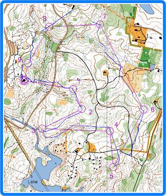
#1: used the trail, then cut down to the bridge and used indistinct trail on the other side to reach the road; then followed the elevation line to reach the control. I think I would have been better of running higher or lower, as I had to cross very deep gullies along the way.
#2: had to go over the hill to avoid fallen trees; then went up the re-entrant and to the control on a right side (it was visible from far away)
#3: again ran without loosing or gaining elevation, noticing top parts of dry ditches along the way; when reached the western slope turned right to the control
#4: made a small mistake when exiting the control but quickly corrected it and followed the creek all the way to the road (without crossing the creek); crossed the road and went east till I saw the dry ditch, followed it and cut south to the control
#5: just ran south, reached the road not far away from the building, continued south and followed the hill down to the control. Was very tired at this stage and decided to cut to Brown.
#6: walked back to the road, then used the road and trail to get close to the control; cut north-north-east, saw the control from far away. I think it was about 20 yards west from the point on the map, but not 100% sure about it.
#7: walked almost to the field, then ran on the field and then used the trail to get as close to the control as possible; cut across the creek, walked up and around the hill, then ran north to the control
#8: ran down and across the creek then made a mistake. For some reason I thought that re-entrant on my left was the one by the road, but it was the middle one (of course). Anyway I ended up walking up all the way to the building, where I realized what happened. From there I simply ran down all the way to the control.
#9: went down to the creek and walked up on the left of the platform, then used trails to get closer to the control and took it
#10: tired, walked up to the trail and ran to the finish.
Time spent on the course: 43 min 55 sec
Here is my route. Click on the image to enlarge. Blue - mostly running, yellow-brown - mostly walking.
Monday, February 23, 2009
February 22 event in North Umstead
Labels:
event,
north umstead park
Subscribe to:
Post Comments (Atom)
No comments:
Post a Comment