Sunday, October 19, 2008

October 19 event in the South Umstead Park (Whispering Pines)

South Umstead and Whispering Pines? Not quite. White, Yellow and Orange course were indeed in that area, but advanced courses were set in the eastern part of park, way north east from the Whispering Pines Camp. With remote start and remote finish all advanced courses pretty much gained 3 extra kilometers or so. Some people didn't like it, but most did. The courses turned out to be quite challenging and orienteerers got to visit some new areas of the park, which is always nice when taking in account how many meets we do have in Umstead throughout the year.

The weather was perfect and turnaround was beyond expectations. What can I say, all the maps (except for 8 advanced ones) got spent! I don't know how Joseph guessed the exact numbers for each course, but somehow he did!

Also so many people helped with this event, especially with the controls pickup despite the controls being so far away! I am very grateful. Thank you very much! Here is the full list (and I hope I didn't mess up the names...):

  • Joseph Huberman and Ruth Bromer - help with courses design, beginners class and maps printing.
  • Holly Kuestner, Molly Nicol, Nadya and Charles Scharlau, Larisa Nord, Artem Kazantsev, Terese Camp - controls pickup.

And, of course, Michael helped tremendously. While it was my and Tanya's names that appeared on the schedule for this event, it was Michael who did a lot today to make the event a success. Tanya had to spent almost all day in the Raleigh Little Theater setting lights for the next show, so she drove us into the park around 9.30 AM and returned only around 3 PM just in time to help with controls pickup. One smart decision we made was to take a bike to the meet. With advanced controls being so far away, it would had been very hard to set the ones visible from the road in the morning. But using the bike, Michael was able to turn around very quickly. Then he set eastern part of white and yellow controls, while I was setting the tables up. When he returned, I ran and set the rest of white, yellow and orange controls. So, by 11.15 we were ready.

People started to arrive shortly after that and soon enough there was a huge line to the register where I was working. I want to apologize for you having to wait in the line... Having remote start and finish for advanced course slowed the process, as I had to explain how it worked. Michael was working at the start, and there were no delays there. The next two hours were a blur for me - so many people showed up! I can hardly remember details, I know only that Joseph did the class somewhere around that time and then I ran out of the maps. Fortunately, everyone got the map they asked for, but we were very close to upsetting someone.

Then people started finishing and to my relief everyone seemed to like the courses. The only critique I got was about a legend for the control 69 (#9 of Red/Green). I should have specify that the control was in western dry ditch, instead of just dry ditch. The most difficult control proved to be 65 (#5 on advanced courses) - a lot of people had troubles finding it clearly from the first attempt. Also 45 (#3) and 41 (#11) caused some delays.

All in all, very good event. I am happy with the way it went and I am very grateful for all the help I had received prior and during this event.

Till the next time!

Saturday, October 18, 2008

One day till the event

Tomorrow is the event.

Almost a month away from the country, away from the forest (except for 5 hours mushroom picking hike in Belarus) - it was such a pleasure to set advanced controls today.

Tanya and I went out to the Umstead and set all remote controls. Tanya set Orange ones and I basically ran the Red course. Two ribbons were missing, other than that everything went fine and we managed within 1 hour and 45 minutes. My personal feeling is that the advanced courses will be rather hard, a lot of hills. But we'll see.

See you tomorrow!

Monday, September 15, 2008

Preparing for the Oct 19 event in South Umstead

I will be out of country from Sep 21 till Oct 11, so this week was the only time I left for the preparation of the Oct 19 event. It will be in Whispering Pines, but the courses will be set in such a way that they won't intersect in any way with Sep 21 event courses. In fact, Red, Green and Brown courses will have a remote start and finish and will touch areas of the park I personally have never been before!

Here is where the advanced courses will reside:


Very physically demanding courses, if I may add. A lot of up and down running, plus long walk to the start. Beware :-)

Anyway, I designed the course on Friday and Joseph and Ruth made several fixes and great suggestions (thank you!), so now the courses are final, pending only the park's approval.

On Sunday I went and hanged ribbons on all advanced controls and a few orange ones. What can I say. A lot of hills are out there.
Saw a few tortoises and a big black snake (a little less than 2 yards). The snake was right under the tree where I was going to hang a ribbon, so we stayed there cautiously watching each other for a few minutes before the snake decided to move away.

The only thing remaining before I go for the trip is to visit all white, yellow and orange controls and write down their legends. I think I'll do it on Tuesday evening, but we'll see.

Monday, September 8, 2008

Sprints at the Lake Johnson

The final sprint event. Right from the beginning I want to thank Josef, Ken, Terese and everybody else who participated in organizing these events. This was the best orienteering summer I ever had. Thank you very much!

Now, back to this final sprint event. Ironically, being in September, it was the hottest one. Very hot and humid, but fortunately not many hills and some of them avoidable.

As I wrote before, I like sprints. And this summer only strengthened this feeling. Plus I did well on both courses (first and second places). This time I avoided making big mistakes. Pretty much the only thing that slowed me was my inability to run uphill in such weather. I ended up walking quite a bit during both courses.

Here are the reports.

Sprint A

#1: Right from the beginning I wasn't going to loose an inch of elevation, so I used the road instead of going down to the lake. It also helped me to avoid a nasty green in the control's re-entrant. Now looking at the splits it seems that the route I chose was indeed the best one.
#2: I simply took a compass bearing and went straight to the beginning of the trail that would lead me to the control. I saw Joseph running from #1 to the right (using another route up the re-entrant) and was actually surprised, as my "straight" path was 90 degrees off his route!
#3: I caught up with Joseph at #2 and ran behind him to #3. It was a trail all the way. Apparently we did have the same speed on a trail, so I felt quite comfortable running behind.
#4: For some reason Joseph ran to the right from #3 (which was a wrong direction) and I went to the left, walked uphill and then ran toward the control.
#5: Nothing special, just a few paces away.
#6 and #7: Down to the road, passed the creek and then walked up to #6 and then to #7. I wish I could run up such hills...
#8: I was rather tired after getting up the hill, so I wanted to get to the road as quickly as I could. Thus I ran straight down (it also helped to avoid another green area). Then used the road to get to #8.
#9: Just went straight over the hill (well, actually a little bit to the right, to avoid getting a few extra feet of elevation). Had to walk again on the way up.
#10: Walked up, up and up...
#11: Used the road and then cut through the wood a few yards after the slight road bend.
And then finish (17.24)

Here is my route. Click on the image to enlarge.


Sprint B

This sprint was tougher. I didn't make big mistakes, but I didn't run as clean as during the Sprint A and I was generally slower.

#1: Down to the trail and then till the control.
#2: Remembering the green re-entrant from the previous course, I consciously made a big curve around it. It also allowed me to stay on the same elevation. However, because if this route, I didn't spot the control right away and lost a few seconds there looking for it.
#3: Used trail until it went down to a small depression, then went south till I saw the pits.
#4: Nothing special, a straight cut. The only delay was at the very control. I got to the bend of the creek, but couldn't see a control there. Instead there was one of the runners looking at his map. I hesitated, but then decided that I couldn't be that wrong and control should be right there. I ran toward the runner and then noticed a control behind him! Virtually hidden by his body...
#5: Walked over the hill and it was there.
#6: I just ran toward the trail while staying on the same elevation. Saw #7, then used the trail to get to #6.
#7: Simply ran back.
#8: Used the trail and then "unmapped" shortcut trail to get to the control area. Saw the dry ditch from the trail and went up to the control.
#9: Used trails to get to the road and then cut through to the control. Felt very tired there and missed the control, then spent 15-20 seconds gathering my thoughts and catching my breath before running toward the control.
#10: Used the road to get around the green area and re-entrant. After the re-entrant went straight north to the control.
#11: Another curve around green re-entrant.
#12: Very tired run... and then finish (18.41).

Here is my route. Click on the image to enlarge.


P.S. I will be out of country from Sep 20 till Oct 11, so unfortunately I will miss the next two events... Then Tanya and I will be organizing the October 19 event. It looks like the next time I will be competing in an event will be in November...

Sunday, August 17, 2008

Sprints in the Crab Tree Lake park

Mixed results and mixed feelings from today's sprints.

I won Sprint B with a good time, but I got disqualified on Sprint A (and rightfully so). Actually I am quite embarrassed by the way I ran Sprint A. Not by the wrong control I took but by the way I completely lost orientation between controls 6 and 7. But read on...

Sprint A

#1: easy, used the trail to go over re-entrant and then shot straight to the control.
#2: exited the control badly and ended up more to the right than I wanted, then ran north up the hill and took advantage of one of the numerous trails up there. Then went down to the re-entrant and found the wet depression spot. From there took compass bearing a little bit to the right of the control and went up the hill. Soon enough I spotted the control, ran toward it and discovered that the number on the control (#58) was from another course. Oops. However, I was quite sure that I was in the right place. I looked around, didn't see the second control (which by the way was hidden 10 yards further to the right), went west hoping to find the correct control there. Of course, I didn't find it there, hit the trail and decided to double-check if the wet depression was indeed the one on the map (the reason was that there was no water in it). So I ran by the trails, found the depression again, took another compass bearing this time to the left of the control, ran up and found the same wrong #58... At that time I decided that the controls were switched and continued to #3. And that's how I got disqualified.
#3: I took a quick compass bearing and ran approximately west-west-north. It turned out that I went a bit further north than I wanted, so I reached the power line (was it a power line?) by the trail crossing it. From there I went down the re-entrant using the trail and soon enough found the control.
#4: Here goes my second big mistake. I went up north re-entrant and then went north-west toward a re-entrant which would had lead me to the control. But instead I found another re-entrant 100 yards south and mistakenly went down it all the way to the creek. The creek there had steep banks and big curves, so I realized my mistake right away and decided to go along the creek until I see two creeks crossing from where I could go straight to the control. I didn't see the crossing though and ended up at the trail crossing the creek. Hmm. OK. From there I finally went over the small hill to the control.
#5: Thankfully, #5 was easy to find. I just ran up the re-entrant using the east slope thus avoiding green area at the top.
#6: South, using a trail in the middle, then down to the re-entrant.
#7: Now this is the part I am embarrassed to tell about... I was going to go further down the re-entrant, then up to the power line, up to the hill and then use trail to get to the control. So I ran down the re-entrant and then something happened. I honestly don't know how I ended up at the road instead of the power line. I guess my mind just blacked out or something. I have no recollection of that part of my route. Anyway I reached the road and somehow accepted it as the power line. I vaguely remember myself musing why there were cars driving on the power line, but even that didn't alarmed me enough to think clearly... So... According to my initial plan I ran up the hill on "the power line", then went left to the trail and "ran toward the control". Only when I reached some strange benches on the trail I realized that something was amiss. And bingo! I looked at the compass. Ouch. I stopped, oriented the map properly, realized where I was, ran back by the same trail till the parking lot, then went east up the re-entrant till the control.
#8: I ran straight south ignoring trails till I got to the control.
#9: The same, south, using corner of the parking lot as an attack point.
And then finish (31.06).

Here is my route. Click on the image to enlarge.


Sprint B

As a redemption to the Sprint A failure I ran Sprint B without making any mistakes.
#1: Used the trail to go over re-entrant and then followed the paved trail to the control.
#2: Simply ran toward the control and found it right away
#3: Ran north-east and down the slope till I hit a corner of the trail, then used the trail to get to the gully and went up to the control.
#4: Used the trail to go down, then crossed the creek and went up to another trail. Followed that trail till the sharp curve and got the control from there.
#5: Decided to ignore a cobweb of trails and used terrain instead. Went north-east, crossed the creek, noticed a re-entrant on the right, but continued north-east over the hill to the correct re-entrant, then went up till the control.
#6: Compass bearing.
#7: Another compass bearing. Counted trails I crossed and, when I hit the right one, looked for the curve and found the pit from there. At that point I also felt sharp pain in my bad knee and ran the rest of the course slower and very carefully.
#8: Just ran south, the control was hidden from that side, but I've already been there twice during Sprint A.
#9: Another compass bearing. I saw a trail to the left when I was running, but the forest was very clear, so I just continued till I hit the trail curve and took the control from there.
#10: Used the trail a little bit to avoid loosing too much elevation, then ran south.
And straight south to the finish (18.40).

Here is my route. Click on the image to enlarge.


Yet again, big thanks to Josef, Ken and Terese for organizing these sprint events!

Tuesday, July 8, 2008

Bubba Goat?

A few weeks ago I was standing in line for an ice cream wearing one of my Umstead 007 shirts when I got suddenly approached by a men who asked:
"Are you with BOK?"
"Well, yes..."
"When will you do another Bubba Goat event?"
"I don't know... Why?"
Then he told me that he is a member of a "rescue squad" and that he and his colleagues participated in the last Bubba Goat event a few years ago and since then patiently waiting for another opportunity to run through the woods. I was like "oh, erm... I'll bring it up to the klub..."

So, I am bringing it up now. Why don't we do another Bubba Goat event early next year? I is always fun.

Monday, June 23, 2008

Sprints in the North Umstead

I like sprints.

Many controls, no consecutive long legs, in fact, no long legs at all, short. My main strength (ability to read and follow intricate features) is emphasized while my main weakness (lack of physical strength and endurance) is not a big factor. As a result, I usually do well in sprints. And this time wasn't an exception.

OK. Let's start from the beginning. The weather. Well, comparing to the last meet, the weather was perfect. Still a bit too humid and warm, but, hey, it's the end of June in North Carolina!

Michael decided to stay in bed, but Tanya and I were at the start shortly after 9 AM. Some people were already finishing!

A decided to go on the longer course first and get it out of the way before I get too tired.

Sprint A

#40: down the re-entrant till I found and punched (!) the wrong control. Oh, boy. Looked at the control number, went further down and took the right one.
#41: compass bearing straight to the road, then noticed a re-entrant on the left, crossed the road and went up till I hit the dry ditch with the control.
#42: very easy, compass bearing right to the control.
#43: didn't go all the way up the hill, but instead went east, noticed the dry ditch and then the re-entrant (my attack point). Went north-north-east, got distracted by the wrong control (#51), stayed there, rested and gathered my thoughts, then went further north to the #43 (jumping ahead, I visited #43 three more times later on!!!).
#44: compass bearing aiming to the left of the control, crossed the creek, went to the right and took it (and, yes, it was set a bit off, but I noticed it only when I was picking up this control).
#45: easy, over the hill to the re-entrant
#46: decided not to gain any elevation and went down to the creek there. It proved to be a good decision.
#47: intentionally went for #41 and used it as an attack point
#48: crossed the re-entrant, went down to the road and then straight to the control.
#49: walked (tired already) up till the trail, then used the trail to get to the control.
And finish.
It took me 24 minutes and 48 seconds to complete this course (2.4 KM) and I won. I hadn't made any significant mistakes, though it could have been faster if I could avoid walking and resting.

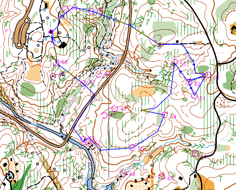
Here is my route. Click on the image to enlarge. Blue - mostly running, yellow-brown - mostly walking, red dots - resting.


Sprint B

After I finished the sprint A, I rested for about 20-30 minutes and went off to the second course. This one proved to be harder for me: mostly physically, plus I made a few mistakes. Though I won this sprint too, looking at the splits, I won only one of ten legs there. I clearly wasn't the fastest runner out there, I was just being more consistent.

#50: (the only leg I won) used the trail and crossed the re-entrant very close to #49, thus avoiding a lot of green, then went east to the control.
#51: made good route decision but didn't executed it well. I did not want to use the big re-entrant with fallen trees and stuff, so I went to the small camping area instead (had to walk uphill occasionally), then used the road to go around the green area and shot for the control from there. Till that point I was doing good. Then I saw control #52 on the left and went to check the number (stupid, huh?). Of course, it was the wrong control. OK, a few yards further and I saw control #43 and, yes, went to check the number again (very stupid). And, finally, after I visited ALL controls in the area I allowed myself to proceed to the one I was actually looking for.
#52: well, I just went from there, so it wasn't hard to find it again
#53: compass bearing from #43, nothing special.
#54: my second mistake. Took compass bearing, but veered to the right and ended up not quite sure about where I was. I knew that I missed the re-entrant, but couldn't decide whether I went left of it or right of it. Went a little bit more to the right, didn't see the re-entrant and correctly decided that I could not have gone so much left of it. So went to the left and took the control.
#55: went down the hill a bit and then along the slope noticing small re-entrants till I got to the dry-ditch with the control in it.
#56: went west, then along the slope, on top of the #42 and down to #56 (people got stung by bees there, Tanya too, but I didn't notice any).
#57: to the road, then used the road to reach the re-entrant (attack point) and went straight to the control.
#58: tiredly walked uphill, then down to the gully
Finish: again tiredly walked up, then ran a little bit to the finish.

It took me 22 minutes and 43 seconds to complete this course (2.0KM)

Here is my route. Click on the image to enlarge. Blue - mostly running, yellow-brown - mostly walking, red dots - resting.


All in all, very good day. Huge thanks to Josef, Ken and Terese for organizing the event. The only bad news is that it looks like I will miss July 19 sprint. I wish it would be on Sunday next day, but, oh well.