I like sprints.
Many controls, no consecutive long legs, in fact, no long legs at all, short. My main strength (ability to read and follow intricate features) is emphasized while my main weakness (lack of physical strength and endurance) is not a big factor. As a result, I usually do well in sprints. And this time wasn't an exception.
OK. Let's start from the beginning. The weather. Well, comparing to the last meet, the weather was perfect. Still a bit too humid and warm, but, hey, it's the end of June in North Carolina!
Michael decided to stay in bed, but Tanya and I were at the start shortly after 9 AM. Some people were already finishing!
A decided to go on the longer course first and get it out of the way before I get too tired.
Sprint A
#40: down the re-entrant till I found and punched (!) the wrong control. Oh, boy. Looked at the control number, went further down and took the right one.
#41: compass bearing straight to the road, then noticed a re-entrant on the left, crossed the road and went up till I hit the dry ditch with the control.
#42: very easy, compass bearing right to the control.
#43: didn't go all the way up the hill, but instead went east, noticed the dry ditch and then the re-entrant (my attack point). Went north-north-east, got distracted by the wrong control (#51), stayed there, rested and gathered my thoughts, then went further north to the #43 (jumping ahead, I visited #43 three more times later on!!!).
#44: compass bearing aiming to the left of the control, crossed the creek, went to the right and took it (and, yes, it was set a bit off, but I noticed it only when I was picking up this control).
#45: easy, over the hill to the re-entrant
#46: decided not to gain any elevation and went down to the creek there. It proved to be a good decision.
#47: intentionally went for #41 and used it as an attack point
#48: crossed the re-entrant, went down to the road and then straight to the control.
#49: walked (tired already) up till the trail, then used the trail to get to the control.
And finish.
It took me 24 minutes and 48 seconds to complete this course (2.4 KM) and I won. I hadn't made any significant mistakes, though it could have been faster if I could avoid walking and resting.
Here is my route. Click on the image to enlarge. Blue - mostly running, yellow-brown - mostly walking, red dots - resting.
Sprint B
After I finished the sprint A, I rested for about 20-30 minutes and went off to the second course. This one proved to be harder for me: mostly physically, plus I made a few mistakes. Though I won this sprint too, looking at the splits, I won only one of ten legs there. I clearly wasn't the fastest runner out there, I was just being more consistent.
#50: (the only leg I won) used the trail and crossed the re-entrant very close to #49, thus avoiding a lot of green, then went east to the control.
#51: made good route decision but didn't executed it well. I did not want to use the big re-entrant with fallen trees and stuff, so I went to the small camping area instead (had to walk uphill occasionally), then used the road to go around the green area and shot for the control from there. Till that point I was doing good. Then I saw control #52 on the left and went to check the number (stupid, huh?). Of course, it was the wrong control. OK, a few yards further and I saw control #43 and, yes, went to check the number again (very stupid). And, finally, after I visited ALL controls in the area I allowed myself to proceed to the one I was actually looking for.
#52: well, I just went from there, so it wasn't hard to find it again
#53: compass bearing from #43, nothing special.
#54: my second mistake. Took compass bearing, but veered to the right and ended up not quite sure about where I was. I knew that I missed the re-entrant, but couldn't decide whether I went left of it or right of it. Went a little bit more to the right, didn't see the re-entrant and correctly decided that I could not have gone so much left of it. So went to the left and took the control.
#55: went down the hill a bit and then along the slope noticing small re-entrants till I got to the dry-ditch with the control in it.
#56: went west, then along the slope, on top of the #42 and down to #56 (people got stung by bees there, Tanya too, but I didn't notice any).
#57: to the road, then used the road to reach the re-entrant (attack point) and went straight to the control.
#58: tiredly walked uphill, then down to the gully
Finish: again tiredly walked up, then ran a little bit to the finish.
It took me 22 minutes and 43 seconds to complete this course (2.0KM)
Here is my route. Click on the image to enlarge. Blue - mostly running, yellow-brown - mostly walking, red dots - resting.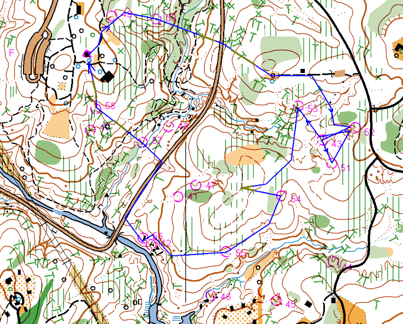
All in all, very good day. Huge thanks to Josef, Ken and Terese for organizing the event. The only bad news is that it looks like I will miss July 19 sprint. I wish it would be on Sunday next day, but, oh well.
Monday, June 23, 2008
Sprints in the North Umstead


Saturday, June 21, 2008
Orienteering over the phone
In the last few days I was merging two versions of the Umstead park map together. Tedious work, but I did learned quite a few additional OCAD tricks along the way. At the end I bumped into an area west of the Ready Creek Lake which had a lot of differences between two maps, but at the same time was away from majority of other "updated areas". I grew suspicious that this area was updated recently and therefore I should not touch it and asked Joseph about it. He suggested that I should go and look, so I decided to go there today.
Before I went into the park I found several "catchy" differences between two maps in that area and plotted them on one of the paper maps. My plan was to try to find these features or rather "find their absence", thus proving my suspicion. So yeah, I was fully prepared.
Right... When I arrived to the park I realized that forgot my paper map. Bummer. But I had a cell phone with me and so orienteering over the phone started :-)
I walked to the area, called Tanya and asked her to guide me though the features. It was fun. Tanya was giving me detailed description of the area and I was following her directions from feature to feature. We checked them all using this unusual method, it reminded me car rallies, where there are two people in one car: driver and navigator. Same kind of sport, I can see a good potential for a "2 people team" orienteering activity right there.
Wednesday, June 11, 2008
June 8 event in the Umstead Park (Report)
It was deadly hot on Sunday. Literally. 101 degrees, not a laughing matter. It looks like at least one runner fainted on the course and I saw many people in the state beyond normal exhaustion at the finish. It came to no surprise to me, as I was one of them.
We arrived about 11 AM (which was quite late) and it was already very hot. Tanya and Michael decided to go on Orange and I chose Green with a possible shortcut to Brown in mind. Jumping ahead, I did end up using this Brown shortcut and I am very grateful to Ken and Terese for designing the courses that way.
Anyway, I started up pretty good. I even ran for a while!
#1 - down to the creek, then noticed a re-entrant and walked up the hill.
#2 - compass bearing intentionally aiming slightly west of the control, so I knew where to go after I crossed the big creek.
Then the heat started to affect my thinking. I usually don't get tired so early on the course, but with 101 degrees in the air I started to loose concentration while looking for the control #3.
I went down to the creek to avoid an extra re-entrant, then went up using the right one, over the saddle and then I got lost for a few minutes. The forest was quite dense and somehow I ended up in a wrong re-entrant. I went down to the creek, checked my compass and realized that I am further north than I was supposed to be. Corrected the error and took the control #3.
At that point heat totally broke my defenses. I felt dizzy and nearly blacked out. Not a good feeling. I realized that I won't be able to keep running and thought about going back to the finish, but decided to slowly walk toward #4 and see how it goes. Since that point I did not run at all. Instead I walked while carefully choosing routes with less elevation, clear ground and more shade (yes, I noticed that I was indeed trying to avoid any kind of open space out there).
From #3 I went uphill, followed it to the trail bend and shot from there to #4.
#5 - compass bearing to the trail bend and over the hill.
I decided not to go straight to #6 as I was feeling very weak at that point, so I went along the creek and, when I gathered some strength, cut to the north till the control. And there was WATER! I spent 3-4 minutes there, resting and drinking. Then took compass bearing to #9 and with renewed strength set off for it.
Reached the road, noticed the curve and took another compass bearing. Reached the point where the control was supposed to be, but didn't see it. So I stood there in doubt. I could go further and double-check my position, but I was afraid to loose too much elevation by doing so. Fortunately, Josef appeared and pointed me to the control, as it turned out, I was in 15 yards from it.
Then I cut to the road, caught up with Josef and we walked together to #10. There was an urge to go and swim across the lake, but in the condition I was, I knew, I would definitely drown.
After #10 Josef went to finish his Red course, while I took full advantage of the Brown shortcut to the finish. But even with this shortcut it wasn't easy. While going uphill from #10 I had to rest three times before I reached the top. Michael told later on that he actually crawled there, well, I didn't, but I also came kind of close to it.
Then there was a slow walk to the finish. The whole Brown course took only 1 hour and 20 minutes for me, while I felt like I was in the wood for at least 2 hours more than that.
Sometime I think that all orienteerers are crazy...
Here is my route. Click on the image to enlarge. Blue - mostly running, yellow-brown - mostly walking, red dots - resting.
Sunday, June 8, 2008
June 8 event in the Umstead Park
Practically dead.
Ken and Terese saved my life with the Brown shortcut to the finish.
Will write a report tomorrow.
Monday, June 2, 2008
Highlighted map for the Umstead Park
Just a quick update on the latest activities. Joseph asked me to fix the Umstead map a bit, so it could be sold to the park visitors, so that's what I was doing during the last two weekends:
-- Moved the new trail behind the main shelter at Ready Creek entrance to the full map. I had this trails mapped in November last year, but it never got to the park map. Finally, it did :-)
-- Refreshed a bunch of small features in the same area (tables, benches etc.)
-- Mapped a few minor trails in the north part of the park
-- (And the hardest part!) Carefully highlighted all park trail and roads with pink color :-)
Sounds like a lot, but it wasn't much work really - just a few hours here and there. Now Joseph should be able to print the maps and I need to think about the next mapping project.
Monday, May 19, 2008
May 18 event in Schenck Forest
It was one of those days when calendar is too full of entries and every minute counts. Orienteering started at noon, Michael had a soccer game at 2 PM, then he and Tanya were going to the Vertical Edge club to do belaying on a birthday party while I had to be in the airport at 4 PM. So coming to the event we agreed not to spend more than an hour of our courses, which suited me well. Michael went on Yellow, Tanya on Brown and I had chosen Green.
The event was also a significant milestone for me, as the map used there was the one I was working on for the last 6 months. If you read this blog before, you probably saw my posts about mapping in Schenck Forest. So yes, it was all done specifically for this event.
Anyway, back to the course. Tanya and Michael started, but I was still looking at the course. Despite overabundance of trails and other features on the map, Ron was able to set pretty challenging green course, there were indeed several legs to think about carefully. Especially 6-7 and 14-16 ones.
I finally started and made my first mistake right there. I don't know what was it: over-confidence or something else, but I missed the correct re-entrant and overshoot good 60-70 yards until I realized what was going on. Returned back and actually met Tanya right at the control. I think I lost about 2 minutes there.
OK. Control #2 wasn't that hard, but I missed it too! I was running on the trail looking on my left for the re-entrant to appear and apparently missed it. Corrected myself at the small creek crossing, went over the creek, back and took the control. Not a big deal, but I also realized that despite me knowing the map so well, I still better be due-diligent about my orienteering and should treat the course seriously. There were no more mistakes after that (at least I think I have good excuses for other "curves").
In case of #3, #4 and #5 I knew exactly where the controls were going to be, so I was simply making some trade offs between the straight lines, terrain and forest density. Got a bit of a dog leg between #3 and #4. I didn't remember #6, but it was very easy to take from the trail. I met Tanya there again.
Then came the biggest leg on the course. I was already somewhat tired, so from that point on I was trying to avoid any extra elevation and hard forest. I crossed the creek and then avoided using the big re-entrant and went for the hill instead. The reason was that I remembered a lot of fallen trees in that re-entrant, so I took advantage of that knowledge. I ran up the hill, used one of the trails for a little bit, then took compass bearing to the left of the control and ran as straight as I could without paying attention to other trails. It worked out quite well, I hit the fence and went to the right to take the control.
#10 proved somewhat difficult for me to find. I was watching both terrain and trails while getting there but couldn't find the actual control quickly as it was very well hidden in the green.
Went to #11 using the creek as a handrail. Not sure it was the best choice, but at least I avoided climbing up a steep slope, which was a priority for me.
#12 was an easy find from the trail as well as #13. I used trails both times and I didn't go straight. I think it was a right decision. I wonder if anyone of you went straight there?
I knew where #14 was going to be, but nevertheless it took a while to get there. Underbrush was quite dense in that part of the forest. Then I decided to go straight #16. I took compass bearing, but it didn't help much. Underbrush was so thick that I lost a direction and exited it way to the west of the control. Quickly corrected myself, took #16, climbed out of the pit from the second attempt (brrr...) and ran to the finish.
Ended up spending 59.44 - perfect timing :-)
Michael already finished, but Tanya was still in the forest, so I had some time to talk to other runners. Josef, Ken and Terese were talking about possible set of sprint events for this summer. That would be awesome! If there are no issues with getting parks permissions let's do it!
Here is my route. Click on the image to enlarge.
Tuesday, May 6, 2008
Girl Scout Orienteering Event in Umstead
A few weeks ago Artem, Tanya and I volunteered to organize an orienteering event for Girl Scouts on May 4. As the date approached Artem designed a yellow course and coordinated all the logistics. There were really no work for me and Tanya until the actual event day.
On May 4th, we left the home early, picked up the maps from Joseph's porch and met Artem at the Girl Scout's camp parking lot in the North Umstead. Splitted the controls between three of us and set them quickly. Then Artem teached the class. It was hard. Imagine 19 nine years old girls and 4 parents, girls loosing attention all the time and parents trying to keep the discipline and at the same time listen to Artem. The hardest part was alignment of the map and compass - I don't think many students got it... At least not in the group I went with after the class.
Anyway, the class was over and off we went. I decided to go with the group #4, as a lady who chaperoned this group was really struggling with the concepts. She was visibly relieved when I told her that I'll stick with them :-)
Much to my surprise the girls got the idea pretty quick, but it was also clear that they enjoyed rocks and streams more than controls :-) Also half of the girls were always running ahead, while another half lagging behind along with the lady. Speaking about different temperaments!
After control #5 where we had to cross a creek the group started to fell apart. Some of the girls as well as the chaperon lady got tired, while others were trying to push ahead. The only uniting factor were occasional dogs on the trails. Every dog we met was thoroughly petted by the whole group. Girls, what can I say!
But, apparently, there were not enough dogs on the course... By the time we reached control #6, the tired part of the group became very tired and wanted to go back to the camp. It was a pity, as other girls wouldn't mind to finish the course. Fortunately, we also caught up with the group #3 and were able to re-group: girls who wanted to proceed went with that group and I walked the tired ones up to the hill and to the camp.
Artem and Tanya were already there and 45 minutes later everybody has finished. It looks like they liked the activity. And a tortoise they found on the course made the day!
Who knows, it might be the same one I saw sitting on top of the ribbon a month ago during the April event.
