It was a tough one... The courses were beautifully designed and non-man-made feature map made them even more challenging. I liked that, but it didn't go very well for me. I lost a lot of time on two controls: one was caused by the map (I can't put it down as my mistake), but the second one was clearly due to my fault and I lost almost 15 mins there! I think there was another leg where I lost 3-4 mins as well. Plus I was soooo tired after control #11 - at times I could barely walk. Clearly I am not ready for 7.3KM red courses at the moment...
Here is how I ran:
#1: used the trail until the fence and then went straight down to the creek, crossed it, saw the cliff on my left and went up diagonally to the control
#2: walked up to the road, crossed it and proceeded along the re-entrant, saw gullies on my right, went over the hill to the re-entrant with the control
#3: went north, crossed the re-entrant, then proceeded north-east on the north slope of the spur to the control
#4: to the re-entrant, passed the gullies and dry-ditches, went up a bit and proceeded along the slope to the control
#5: north up the hill (but not to the top), then stayed on the same elevation until I saw the re-entrant in front of me, turned right along the slope to the control
#6: crossed the re-entrant, walked up the hill, then down, crossed the creek, up the hill again and proceeded on high ground monitoring re-entrant on my left; after I reached the side re-entrant turned right to the control
#7: down to the main re-entrant, ran along it, passed the big side re-entrant on my left and walked north up the hill there; saw a top of a small side re-entrant on my right, kept going north across the hill, reached the other side, saw another small side re-entrant there, proceeded along the slope, saw the hill curving to the right and cut to the control. Reached the huge pile of rocks and stopped in disbelief. There was supposed to be a control - not rocks! In fact there were no rocks on the map. What was going on?!! Well... As it turned out the control was on the other side of the pile, but I didn't know that, because it never occurred to me to look at the legend, while the rock pile wasn't on the map because it was removed from the "no-man-made features" map I used. Apparently it was marked there as a stone wall (which actually wasn't correct, I think).
Anyway,.. I went further north along the slope, then realized that it didn't look right at all, decided to take another bearing, went down to the creek, walked south, found the dry ditch, went up and found the same huge pile of rocks. There I finally decided to check the legend and realized what was going on... Went around the pile and found the control.
One lesson learned for the future is that we should not put controls on "man-made features" when offering "non-man-made features" maps option.
#8: went north-west up the hill, then (when I reached the top) turned west to the control
#9: west down the slope, watched re-entrant on my left, crossed the road and creek, saw the re-entrant, crossed the trail, went up the slope of the re-entrant to the dry-ditch with the control
#10: went north and actually counted small shallow re-entrants while doing so till I reached one with the control
#11: up and across the hill, saw re-entrant on my left, but continued north and reached the creek near the gully, crossed the creek, noticed small re-entrant on the other side and from there cut to the control, saw rocky ground and the re-entrant (or something that looked like one), but no control. I am not sure why. Maybe I was looking at the control from the side (it was hanging flat), or maybe I was indeed a bit off - not sure. I went down a bit and then west trying to find the control, but no luck. I was getting quite confused at that moment and decided that I better start it all over. So I went down to the creek, reached the creek but wasn't exactly sure where, so I proceeded along the creek with an idea that sooner or later I'll position myself on the map correctly. Ended up walking all the way to the very distinct gully on the left side on the creek, went up and then west to the control. Found it. I think I spent 15 extra mins on this one...
#12: I guess I was quite upset then, so I made another mistake right there. Instead of going north west, I went west-west-south and ended up on the hill way south of the control. I wasn't lost, just way off... Went north along the hill, didn't see the control right away, but then saw the big tree and went there
#13: down the slope, crossed the re-entrant, up and proceeded west along the hill until I saw the big pile of rocks, from there saw the control
#14: south around the re-entrant, then south-west along the hill, saw re-entrant on my right, passed it and went down along the other the re-entrant which lead me south to the creek; there I saw those weird earth formations, went to the other side of the creek and to the cliff with the control.
#15: crawled up the cliff and lost all the strength... Felt terrible and for a while could barely walk. South, around the re-entrant, reached and crossed the trail, went around all the gullies, across the hill and down on the other side, ended up too far to the right, so corrected myself and went left to the control
#16: went around all the re-entrants and across the hill, then down to the road, crossed in and went diagonally to the saddle with the control
#17: back to the road, used it and then used the trail to get to the dry-ditch with the control
#18: down to the creek, ran along it for a bit, then crossed it and reached the road right below the intersection, crossed the road and reached the trail, used it for a bit then went up and proceeded along the slope counting gullies to the control
#19: very tired... just walked further along the slope to the re-entrant and gully with the control
finish: again very tired... tried to avoid big hills, so ignored all the trails and simply walked south west through everything till I reached the paved trail, from there ran to the finish.
It took me: 102 mins 39 secs
Here is my route (blue - mostly running, brown - mostly walking). Click on the image to enlarge.
Huge thanks to Ken and Terese for organizing the event!
Monday, February 28, 2011
Feb 27 in North Umstead
Sunday, September 19, 2010
Sep 19, 2010 in North Umstead
North Umstead is my favorite "half" of the park. It's less hilly comparing to the "south", relatively open, thus it's usually a pleasure to run there. It would have been a pleasure today too - Artem and Holly set awesome courses - but right after the second control I got poked in a eye by a small twig and lost one of the contact lenses... That changed everything. Suddenly the course gained elements of a "survival" game. Double vision was no fun... A mixture of blur and perfect picture was quite unnerving, misleading and even dangerous. I actually felt better with one eye closed, but simply couldn't keep it shut. I could still see the map and read the forest and terrain, but observing my immediate surrounding became a challenge. Jumping over trees and ditches was tough - my brain refused to judge distance properly and I ended up falling a few times while attempting to jump over dried creeks. Also it became hard to avoid low branches and cobwebs as well as noticing the actual controls (fortunately Holly set them pretty high, thank you!). Finally I had to take into account my vision deficiency when choosing the routes.
But despite all that, I did rather good. No big mistakes, maybe two or three 1 minute ones. Orienteering was mostly easy with only a few hard legs. Of course, I didn't run uphill at all and also slowed down considerably at the end, but 64 mins on 5.3 km was decent. As far as choosing direction of the run, I picked the one which offered longer run before Red/Green decision point.
Here is how I ran:
#1: south-south-east, carefully watching for the re-entrant to start forming on the other side of the hill. When it was there, simply ran down.
#2: along the creek to the road and continued on the other side along the dry ditch but about 15 yards to the left on the slope. Got to the control, but couldn't spot it for a few seconds.
#3: south-east-east to the road, immediately crossed it and reached the trail. Used the trail thinking about cutting down from the first turn, but saw how many fallen trees were in the green area and continued on the trail until the next turn. From there went across the road and down to the control. Got poked in the eye and lost the lens... Spent some time trying to find it, couldn't and continued further down. Crossed the creek, up the little spur and went south on it looking for the control.
#4: south along the creek, crossed it and went up the hill bearing to the left, so I would be definitely to the left of the control. On the other side went to the right and took the control.
#5: down and long the creek for a bit but quickly went across the hill, re-entrant and up the slope. Then continued on the slope until the dry-ditch with the control.
#6: east, down the slope, crossed the creek, didn't see creeks crossing but could see the re-entrant, used the left slope to get to the control.
#7: tried to reach the road by going up the hill south-south-east, but ended up to far east and reached the road about 100 yards further than I wanted. Used the road until I saw the sharp bend and cut to the control.
#8: to the trail. I didn't even think about going uphill there, so used the trail as much as I could and when I reach the distinct bent went south-west carefully looking for the re-entrant to start forming, It was very flat and quite challenging, but I got there anyway.
#9: went down to the big creek without getting into the side re-entrant and reached the creek right at the junction. That was nice, I simply went up the slope and to the control.
#10: I was getting tired, plus my vision problem, so I decided to stay on Green. Walked up to the west and reached the opening with ruins. There I realized that barbed wire is somewhere in the area. I wouldn't be able to see it in my condition, so I decided to so a bit south so I could definitely avoid it. Then continued west, reached the road, crossed it and continued further west aiming to the hill between two re-entrants around the controls. Crossed the power line and went down the hill to the control.
#11: to the trail and used it as far as I could. However, I didn't realize that the trail is supposed to go away from the creek at the end and continued along the creek, over the rocks to the very dead end by the dam. There I finally realized what happened, but I didn't have much choice and had to literally rock clime out of there. That climb did me in... I was walking most of the way after that. Anyway, after I climbed up I immediately saw the re-entrant and went to the control.
#12: over the hill, crossed the re-entrant, over the next hill aiming a bit to the left, then went to the right to the control.
#13: up north, reached the big building, across the field. Decided to go around the green area from the south, so cut north right after the little building at the end of the field. Missed and reached the creek almost at the opening. Corrected the mistake and went east to the control.
#14: north-west carefully looking for the re-entrant to start forming. Finally reached it, but further north than I wanted. Had to return south a bit to the control.
#15: down to the road and to the control on the other side
and then up the hill crossing everything to the finish. It took me 63 mins 58 secs.
Here is my route (blue - mostly running, brown - mostly walking). Click on the image to enlarge.
Huge thanks to Artem and Holly for the great event!
Saturday, July 4, 2009
Preparing for the July 12 event
Everything is ready :-)
Two 2.4 km sprint courses got approved by the park and today I set the ribbons. 17 controls, 9 controls on each course. I designed them as two loops (in opposite directions) around the parking area, thus avoiding any camp areas we've had troubles with the park rangers about. And, indeed, the approval was easy (that is, no corrections were required). Also remapped the trail in the north west corner of the map below.
Here is the area where the courses are set in:
See you there at July 12!
Sunday, June 7, 2009
June 7 at North Umstead
Brian promised an interesting courses today, and, indeed, the Green course I ran was quite unusual. What added to the challenge is "unevenness" of the course. Normally, all controls on advanced courses have similar degree of difficulty and are similarly placed, so runners could mentally adjust to the course after the first few controls. Not this time. Some controls were very easy (maybe too easy), but others were of very high degree of difficulty. Also some controls were low and hidden, while others hanged very high above the ground. I personally found such mixture quite difficult to adjust to, and ended up making several (medium) mistakes on the course. Mercifully, the weather wasn't very hot for this time of the year, so I was able to run most of the time and thus finished with an "all right" time.
Here is how I ran:
#1: down to the dry ditches, through some fallen trees, across the trail and creek, then up about 15 yards from the control. The control was hanged very high and I didn't notice it, ran north east to the cliff to confirm my position - it was correct. Returned back and saw the control this time.
#2: across the road and up the re-entrant, then used a gully as an attack point
#3: ran on the elevation line, missed the control as it was lying on the ground, but saw big rocks. Turned around and saw the control.
#4: to the road, then used the trail to get close to the control. Noticed one re-entrant on the left, then turned into the second one.
#5: ran across two creeks, then noticed a trail going by the shore and used it instead of cutting over over the hill. The trail lead me basically to the very control, I just needed to watch the shore line and get down to it where the control was placed.
#6: climbed up the slope, ran across the re-entrant and walked up to the control
#7: very difficult control: in a pit, on a flat, without good attack points. Ran by the top of the re-entrant, then aimed to the right (west) of the control and ran across the hill (probably missed a bit), then turned left looking for the pit. Didn't find it and noticed some not very distinct re-entrants, realized that I must have missed the pit and ran back. Found the pit this time.
#8: another difficult one: no sharp elevation features, no good attack points (rocks don't count as they were separated from the control by the green area). Anyway. Crossed the creek and went up watching re-entrant on my left, then aimed to the eastern side of the green area and went over the hill there. Went down the slope a little bit and turned right to the control.
#9: made my biggest mistake there. Went across the re-entrant and aimed for the corner of the restricted area, but missed and hit the creek farther west than I thought. Crossed the creek and went west looking for the re-entrant with the control, naturally, didn't find it and ended up in the re-entrant west of the control. Decided that I was going west for too long, stopped and realized the mistake. Went back and took the control.
#10: went around the re-entrants and reached the road exactly where I wanted - by the re-entrant on the other side. Went down using the northern slope and turned right to the control.
#11: returned back to the road, thought about getting to the trail, but decided to cut straight instead. Aimed to the right of the control, didn't see the trail, but when the slope went down, turned left and took the control.
#12: used the road to get close to the control, but exited to the forest too early. Ended up traversing the northern slope of the big re-entrant, then going north over the green hill. There I wasn't certain whether I was right or left of the re-entrant with the control and decided to go left with an idea of hitting either the re-entrant or the rocks cluster. Found rocks and used them as an attack point.
#13: down to the shore and used the trail and road to get close to the control. Went up to the dry ditch and reached it right by the bridge. The bridge and new trail should have been added to the control's legend. Unfortunately, they weren't, so I didn't look under the bridge and instead went up looking for the control. Didn't find it, returned back and decided to look further down (though I was starting to think that the control was taken away). As soon as I went over the bridge I saw the control right there. Bummer. Lost 2 minutes there...
And then finish with an OK 1:09 time.
Thanks to Brian for such unusual and challenging course!
Here is my route. Click on the image to enlarge. Blue - mostly running, yellow-brown - mostly walking.
Monday, February 23, 2009
February 22 event in North Umstead
It was raining in the morning, so Tanya and Michael decided not to go. Too bad for them. Rain stopped and orienteeres were rewarded by beautiful sunny weather. A bit too cold, but still pretty good.
Ken and Terese designed interesting courses, especially for Red runners. They got two great long legs in the middle of the course. Unfortunately for me, I wasn't running much lately. I knew I couldn't handle Red in such shape and decided to go on Green. During the course I realized that I wasn't fit even for Green and cut to Brown, which left me with the easier part of the route. But anyway, it was good.
Here is how I ran:
#1: used the trail, then cut down to the bridge and used indistinct trail on the other side to reach the road; then followed the elevation line to reach the control. I think I would have been better of running higher or lower, as I had to cross very deep gullies along the way.
#2: had to go over the hill to avoid fallen trees; then went up the re-entrant and to the control on a right side (it was visible from far away)
#3: again ran without loosing or gaining elevation, noticing top parts of dry ditches along the way; when reached the western slope turned right to the control
#4: made a small mistake when exiting the control but quickly corrected it and followed the creek all the way to the road (without crossing the creek); crossed the road and went east till I saw the dry ditch, followed it and cut south to the control
#5: just ran south, reached the road not far away from the building, continued south and followed the hill down to the control. Was very tired at this stage and decided to cut to Brown.
#6: walked back to the road, then used the road and trail to get close to the control; cut north-north-east, saw the control from far away. I think it was about 20 yards west from the point on the map, but not 100% sure about it.
#7: walked almost to the field, then ran on the field and then used the trail to get as close to the control as possible; cut across the creek, walked up and around the hill, then ran north to the control
#8: ran down and across the creek then made a mistake. For some reason I thought that re-entrant on my left was the one by the road, but it was the middle one (of course). Anyway I ended up walking up all the way to the building, where I realized what happened. From there I simply ran down all the way to the control.
#9: went down to the creek and walked up on the left of the platform, then used trails to get closer to the control and took it
#10: tired, walked up to the trail and ran to the finish.
Time spent on the course: 43 min 55 sec
Here is my route. Click on the image to enlarge. Blue - mostly running, yellow-brown - mostly walking.
Sunday, December 7, 2008
December 7 event in the North Umstead Park
It was rather cold. After all it was a December meet, right?..
Actually, I should rather say that it was hot to run, but cold to walk. I am glad I had spare cloths I could change into at the finish.
Tanya and Michael walked the Orange course and I ran Brown. I thought I would do Green, but changed my mind in the middle of the course - after 3 weeks of nurturing my right leg and non running, I was terribly out of shape... I have to do something about it, even if I can't run I should at least ride the bicycle between the meets.
Anyway, to the course. First of all, I liked it: many controls, short/medium legs, clear forest. Thank you, Artem!
All in all I made just one 3-4 minutes mistake, everything else I took the way I intended to.
#1: down to the creek, up to the road and almost straight shot to the re-entrant and gullies with the control.
#2: up the hill, then down to the north-east side of the clearance, which I used as an attack point.
#3: to the "horse" parking lot, then through the camp, crossed re-entrant and went over the ridge to the re-entrant with control (left from the control), then simply ran right till I found it. The reason I went through the parking lot and the camp was that I was looking for an easy terrain to run. I am not sure it was the best decision but I don't regret making it.
#4: up the hill and watched re-entrant on the right side without going into it. Then up to the road.
There I realized that that hill took nearly all my strength and stopped to decide whether I really want to continue on Green or cut to Brown. I decided to cut to Brown.
#5: used the road, didn't see the trail on the left, but saw the re-entrant, went into it and over the hill to the second one and reached a creek. At least I thought it was a creek, in reality it was a ditch - I was 100 yards more to the left than I thought... Naturally, I went left along the "creek" to find the control, but the "creek" disappeared and I realized my mistake. Returned back, reached the true creek and took the control.
#6: walked all the way up to the road, then ran to the control keeping the power line on my right side.
#7: ran west, noticed the small hill on my right, reached the road and navigated to the hill, then ran down the hill till I reached the small cliff with the control.
#8: to the road and used the road's bend as an attack point. Also watched small re-entrant on the left to find the control.
#9: very easy, using small parking space as an attack point.
#10: used the road all the way, then cut across the creek and used trail to get to the control.
#11: used the trail as much as I could, then walked up the hill to the finish.
Spent 40 mins (according to my watch) or 37 mins (according to the printout).
After the finish I sat down with Mihai, he is going to help with Bond Lake park mapping, which is great. I already did some work there (and will write about it later), but there is plenty of work for both of us for this winter.
Tanya, Michal and I also stayed and helped with controls pickup, so I got the chance to take some of the remaining Green/Red controls.
Here is my route. Click on the image to enlarge. Blue - mostly running, yellow-brown - mostly walking.
 |
| From Orienteering |
Monday, June 23, 2008
Sprints in the North Umstead
I like sprints.
Many controls, no consecutive long legs, in fact, no long legs at all, short. My main strength (ability to read and follow intricate features) is emphasized while my main weakness (lack of physical strength and endurance) is not a big factor. As a result, I usually do well in sprints. And this time wasn't an exception.
OK. Let's start from the beginning. The weather. Well, comparing to the last meet, the weather was perfect. Still a bit too humid and warm, but, hey, it's the end of June in North Carolina!
Michael decided to stay in bed, but Tanya and I were at the start shortly after 9 AM. Some people were already finishing!
A decided to go on the longer course first and get it out of the way before I get too tired.
Sprint A
#40: down the re-entrant till I found and punched (!) the wrong control. Oh, boy. Looked at the control number, went further down and took the right one.
#41: compass bearing straight to the road, then noticed a re-entrant on the left, crossed the road and went up till I hit the dry ditch with the control.
#42: very easy, compass bearing right to the control.
#43: didn't go all the way up the hill, but instead went east, noticed the dry ditch and then the re-entrant (my attack point). Went north-north-east, got distracted by the wrong control (#51), stayed there, rested and gathered my thoughts, then went further north to the #43 (jumping ahead, I visited #43 three more times later on!!!).
#44: compass bearing aiming to the left of the control, crossed the creek, went to the right and took it (and, yes, it was set a bit off, but I noticed it only when I was picking up this control).
#45: easy, over the hill to the re-entrant
#46: decided not to gain any elevation and went down to the creek there. It proved to be a good decision.
#47: intentionally went for #41 and used it as an attack point
#48: crossed the re-entrant, went down to the road and then straight to the control.
#49: walked (tired already) up till the trail, then used the trail to get to the control.
And finish.
It took me 24 minutes and 48 seconds to complete this course (2.4 KM) and I won. I hadn't made any significant mistakes, though it could have been faster if I could avoid walking and resting.
Here is my route. Click on the image to enlarge. Blue - mostly running, yellow-brown - mostly walking, red dots - resting.
Sprint B
After I finished the sprint A, I rested for about 20-30 minutes and went off to the second course. This one proved to be harder for me: mostly physically, plus I made a few mistakes. Though I won this sprint too, looking at the splits, I won only one of ten legs there. I clearly wasn't the fastest runner out there, I was just being more consistent.
#50: (the only leg I won) used the trail and crossed the re-entrant very close to #49, thus avoiding a lot of green, then went east to the control.
#51: made good route decision but didn't executed it well. I did not want to use the big re-entrant with fallen trees and stuff, so I went to the small camping area instead (had to walk uphill occasionally), then used the road to go around the green area and shot for the control from there. Till that point I was doing good. Then I saw control #52 on the left and went to check the number (stupid, huh?). Of course, it was the wrong control. OK, a few yards further and I saw control #43 and, yes, went to check the number again (very stupid). And, finally, after I visited ALL controls in the area I allowed myself to proceed to the one I was actually looking for.
#52: well, I just went from there, so it wasn't hard to find it again
#53: compass bearing from #43, nothing special.
#54: my second mistake. Took compass bearing, but veered to the right and ended up not quite sure about where I was. I knew that I missed the re-entrant, but couldn't decide whether I went left of it or right of it. Went a little bit more to the right, didn't see the re-entrant and correctly decided that I could not have gone so much left of it. So went to the left and took the control.
#55: went down the hill a bit and then along the slope noticing small re-entrants till I got to the dry-ditch with the control in it.
#56: went west, then along the slope, on top of the #42 and down to #56 (people got stung by bees there, Tanya too, but I didn't notice any).
#57: to the road, then used the road to reach the re-entrant (attack point) and went straight to the control.
#58: tiredly walked uphill, then down to the gully
Finish: again tiredly walked up, then ran a little bit to the finish.
It took me 22 minutes and 43 seconds to complete this course (2.0KM)
Here is my route. Click on the image to enlarge. Blue - mostly running, yellow-brown - mostly walking, red dots - resting.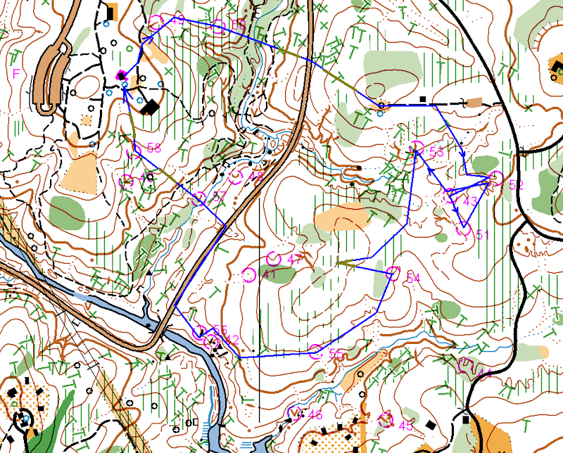
All in all, very good day. Huge thanks to Josef, Ken and Terese for organizing the event. The only bad news is that it looks like I will miss July 19 sprint. I wish it would be on Sunday next day, but, oh well.
Tuesday, May 6, 2008
Girl Scout Orienteering Event in Umstead
A few weeks ago Artem, Tanya and I volunteered to organize an orienteering event for Girl Scouts on May 4. As the date approached Artem designed a yellow course and coordinated all the logistics. There were really no work for me and Tanya until the actual event day.
On May 4th, we left the home early, picked up the maps from Joseph's porch and met Artem at the Girl Scout's camp parking lot in the North Umstead. Splitted the controls between three of us and set them quickly. Then Artem teached the class. It was hard. Imagine 19 nine years old girls and 4 parents, girls loosing attention all the time and parents trying to keep the discipline and at the same time listen to Artem. The hardest part was alignment of the map and compass - I don't think many students got it... At least not in the group I went with after the class.
Anyway, the class was over and off we went. I decided to go with the group #4, as a lady who chaperoned this group was really struggling with the concepts. She was visibly relieved when I told her that I'll stick with them :-)
Much to my surprise the girls got the idea pretty quick, but it was also clear that they enjoyed rocks and streams more than controls :-) Also half of the girls were always running ahead, while another half lagging behind along with the lady. Speaking about different temperaments!
After control #5 where we had to cross a creek the group started to fell apart. Some of the girls as well as the chaperon lady got tired, while others were trying to push ahead. The only uniting factor were occasional dogs on the trails. Every dog we met was thoroughly petted by the whole group. Girls, what can I say!
But, apparently, there were not enough dogs on the course... By the time we reached control #6, the tired part of the group became very tired and wanted to go back to the camp. It was a pity, as other girls wouldn't mind to finish the course. Fortunately, we also caught up with the group #3 and were able to re-group: girls who wanted to proceed went with that group and I walked the tired ones up to the hill and to the camp.
Artem and Tanya were already there and 45 minutes later everybody has finished. It looks like they liked the activity. And a tortoise they found on the course made the day!
Who knows, it might be the same one I saw sitting on top of the ribbon a month ago during the April event.
Sunday, April 13, 2008
April 13 event in the North Umstead Park.
Maybe we should skip "13"s in the future events calendar after all... There was a serious injury today on the red course. Nadya had a head injury, lost a lot of blood and ended up in the hospital with 16 stitches and concussion. She called me this evening and seemed to be recovering fine, but it was a scare. She was also fortunate that Charles was running right by soon after she got hurt. But in the future, please, never ever go on the course without a whistle.
The day started very well though. Perfect weather for orienteering. Tanya and Michael went to Gary's advanced orienteering class (and, by the way, had a great and useful lesson), while I set 20 or so white, yellow and orange controls (2 advanced ones as well). I funny thing happened to me at #43. This advanced control was close to the road, so a week ago I put the ribbon there literally on the ground. Today I was there looking for the ribbon and couldn't find it. I knew it was supposed to be there, so I looked closely and then I saw a turtle sitting right on top of the ribbon and thus hiding it :-) I hanged the control on top and let it be. I wonder if anyone saw the turtle later on at this control.
At 11 AM everything was ready except for the printer... It wouldn't work. No matter what I was doing it wouldn't print. It messed up the event a bit, as Tanya had to explain to everyone that the printer was out, but that download box was still needed (thanks to Memund and Ken for telling us about it). We also tried to write down start/finish time, but I am afraid didn't do it for everyone. I really hope that the problem was with the printer and not the download box, so the results will be there.
Anyway, Josef was the first to start and the event went on. We had a lot of reds and only a few yellows. Kind of strange distribution - for some reason not many kids were in the forest today. It looked like that advanced runners were pleased with the courses: I set controls very low and sometime even hidden, so they could be found only if you find the exact feature - and everyone seemed to like the challenge.
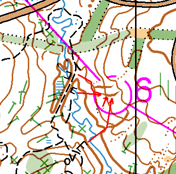
I got thanks for White and Yellow too. The only problematic course was Orange: a few long times and DNFs there and one complain about a control being set incorrectly (in wrong gully). During the controls pick up I went and double-checked that control (#51, #6 on the course), tried it from 4 different attack points and I can confirm that the control was set 100% correctly. Below is the picture with the attack points (from top to bottom):
- leave the trail, notice a dry ditch and a gully, then move south-east to the right gully
- notice a stone wall (bridge) on the creek and take a bearing to the gully
- notice a stony ground by the creek and take a bearing to the gully
- start from the tooth shaped big rocks on the other side of the creek, take a bearing to the big gully and then go north to the right one
There were a few late finishers, but everyone got back. Artem and Bill helped with controls pick-up, Michael took a lot of white and yellow ones and Tanya and I a few others. All in all we were done by 4.30 - rather quick!
Huge thanks to everyone who helped:
- Bill, Artem, Joseph and Ruth with controls pick-up
- Ken with the class (Michel and Gary also offered to teach the class, but Ken was the first)
- Joseph and Ruth with course consulting
- Ken and Joseph with results
Cheers!
P.S. One of the reasons we were so quick with the controls pick-up was that Joseph and Ruth asked us to leave Brown and Green course in the park, so they would run on Monday - so we did. I moved the last control down a bit (to hide it) and inadvertently added one Orange control to these left over Brown and Green courses. It's going to be harder now :-)
Saturday, April 5, 2008
Rain and Ribbons
The park rangers asked us to modify the courses in order to avoid two camp areas, so as a result advanced courses got two easy controls instead of one of the difficult ones. Oh, well... Nothing I can do about it, just don't get surprised when you see those two controls and road between them...
Anyway, now the courses are final and I went into the park to set ribbons today. Tanya couldn't go with me as she had to spend the whole day at the Raleigh Little Theater (preparation for Peter Pan just got started and Tanya is in the deck crew). Jumping ahead, I am glad, that I put my lenses on instead of the glasses! Otherwise, I wouldn't be able to set an many ribbons as I did today.
I started from the Visitors Center and made a big circle (8-9KM) visiting almost all Orange, Brown, Green and Red controls. Spent a lot of time (4 hours), mostly because of the difficulties with dry ditches. Maybe I am imagining things, but it looks like the north part of the park is not mapped as accurately as the south one. So many dry ditches not shown on the map - in some cases it gets really confusing. I spent about 30 minutes on one of the controls (east of the Visitor Center), trying to pin point the exact location of a dry ditch I was looking for. Ouch. Hopefully, I selected the right one (took several different bearings to check), but I am still not as confident there as with other controls. There was also a place where I found two cliffs instead of one (some very curious terrain there). Finally, the power line should have been yellow instead of dark green (not a big deal, as the courses go across).
The rain started soon after I started, but it wasn't cold and I had lenses on, so I decided to keep on going and finished the circle. Ended up totally soaked, but not cold. All in all it was a good walk - and most of the work was done.
There are 4 ribbons remaining for tomorrow, plus while and yellow course to visit. Maybe Tanya or Michael will join me for a walk this time.
Sunday, March 30, 2008
Courses for the April 13 event in North Umstead
Two days ago I received a confirmation from the park management that Umstead North is OK for the April 13 event. Moreover, they told us that we will be able to use a small shelter there for registration and start, which is very nice.
I designed the courses yesterday and after a few minor corrections from Tanya and Joseph, the courses went to the park management for review. If everything goes smoothly here are the parameters:
- White 1.8 KM, 9 controls
- Yellow 2.8 KM, 11 controls
- Orange 3.5 KM, 12 controls
- Brown 4.4 KM 12 controls
- Green 5.5 KM 14 controls
- Red 7.3 KM, 17 controls
Runners will be able to choose between Brown, Green and Red around the middle of the course.
