Night-O is among my favorite events and is probably the most anticipated one. We only do it once a year after all. So, yeah, I've been counting days :)
Also Mihai somehow always manages to add extra twist to the event, whether it is a flood or, in this case, bitter cold and wind. Seriously, it was the first and only really cold evening during the whole winter! After the finish, having crossed creeks a few times, I realized that my pants and shoes were covered in a thin layer of ice! Now, this hadn't happened to me before - even during winter orienteering back in Belarus.
I am not going into too much details about my route - you can see it below, but here are a few highlights:
1. I left the western part of the map for the end because I knew that I was bound to get wet there and I really really didn't want to run the whole course with wet feet in such cold weather. Also I wasn't particularly looking forward getting into thorns which were abundant on that side - and wanted to postpone it as much as I could.
2. I went for 46 right from the start, even though, I knew it was a good finishing control. Still it was on my way, so why not take it right away. I caught up with Brian on the very next control, so it was a right choice.
3. Despite not taking ideal routes from 57 to 58 and 58 to 62, I was able to keep up with Brian. We met at every control up until 56 where he went east and I continued north. I was at 17 mins mark there and figured that there was a high probability of taking all the controls, so naturally I was looking for a route which would include all of them.
4. And I got into trouble on the very next control! Couldn't find it from above, went down to the creek, met Tanya, figured the control got to be higher and more to the west and indeed it was there. Lost a minute or so there.
5. Next two controls also proved to be challenging. First I missed re-entrant with 55 and had to come back. Then I couldn't spot 61 on the hill. Kiwi helped me there! She ran to me and then back to Joseph who was at the control. I simply followed her :)
6. Met Tanya again at 42, then took the trail around the visitors center. Was running and thinking that I should have gone straight instead of going around (but looking at the map now, I could see that the trail was a good option).
7. Reached 44 at 33 min mark - plenty of time left, though, I rightly suspected that it'd be harder in the west part. It was.
8. Crossed the knee deep creek between 54 and 59, tried to climb steep bank on the other side, fell, eventually climbed the bank, ran to the control and realized that I lost the map! Oh, no! I thought it was all over and my map was flowing down the creek... Went back to the bank where I fell and to my great relief found the map - it was hanging on one of those thorny vines.
9. Crossed the creek again between 59 and 66 - being already wet I didn't care anymore :)
10. Couldn't find 68 for a while. It's a tough place without good attack points. I turned into the green a bit too early, but eventually found the control by walking east.
11. Crossed the creek between 65 and 52 and got seriously stuck on some thorny vines. Got scratched all over and managed to make a deep cut on my left thumb, so it started to drip blood to the flashlight handle and the map quite profusely.
12. I had 5 mins left at 51 - just enough to take the last control and finish on time!
All the controls in the bag and final time: 59.52 - couldn't have been better!
Huge thank you to Mihai for yet another great Night-O!
Monday, February 13, 2012
Night-O at Bond Park (Feb 2012)
Sunday, February 13, 2011
Night-O at Bond Park
Night-O's are my favorite events, no doubt about it. It's an ultimate orienteering adventure and a lot of fun. Maybe because of this attitude, or maybe for some other reason, but historically, I always do well at Night-Os. Yesterday wasn't an exception. I had a great run (though not 100% clean - what you expect!). Didn't take all controls, but ended up close (26 out of 30). Got disoriented a few times, but fortunately made right decisions in those situations and avoided wasting a lot of time.
Here is how I ran:
Start: I spent about 20 seconds studying the map under the street light. I noticed that west portion of the map was very populated with controls. It was different from the previous Night-O, when majority of the controls were in the south part. I had to choose where to run first. From one side it was safer to pick a lot of controls right away, but from the other side I would prefer to pick far away south controls as soon as possible, so I would be closer to the finish at the end of the hour. I also noticed that it was possible to take all south controls in one big curve, which was nice. Finally, I remembered that last time I had enough time to visit both sides of the map, though I couldn't take the most north-west control. So finally I decided to go south first, watch the clock and possibly skip some 40ies if necessary.
#40: straight down, across the field to the corner of the forest
#57: went to the road, reached the parking lot and ran to it's south-east end. There I saw an unexpected extra paved road. It wasn't there last year! Got confused because of it and missed he control. Stopped, then decided to take the control from the other side, went to the baseball field and took the control from there.
#58: back to the parking lot, to the beginning of the trail, used it to cross the stream and then went along the stream (or ditch) to the control.
#62: scrambled back to the trail, used it until the "sewer thingy" and cut from there to the control
#71: back to the trail, used it until I saw a cutting on the left, went south-west watching the lake shore line in front of me on both sides.
#70: ran along the shore line, then cut straight to the trail, crossed the bridge and went east, staying at the bottom of the hill but pointing up with my flashlight. Proceeded like that until I saw the control.
#64: ran north, crossing everything until I reached the trail. Used the trail to get close to the control and then used the corner of the baseball field as an attack point.
#63: up to the field, ran along it and then down to the re-entrant with the control.
#56: to the parking lot and used a little trail that goes to the playground. Attacked the control from the trail fork.
To the road on my right and stopped there to think about my next steps. I was in a good shape time-wise: only 18 mins spent. Yet I was still worried about getting to the west side of the park in time. So I decided to skip #42 and take it at the very end if time allows (as it turned out it didn't). I was also in doubt about #60, but decided that I better take it and skip one of western 60ies instead.
#41: north, crossed the parking lot, to the picnic shelter, ran along the tables and them down to the creek. Didn't see the control from the top, but was able to spot it from the bottom.
#55: up to the trail, used the trail for a bit, then cut east to the control
#61: to the road, went left a bit to avoid steep hill, then east across the hill to the re-entrant and up to the control
#50: down to the road, to the crossing, then left, passed the trail and went for the control
#60: straight east to the road, crossed it, to the re-entrant and ran on the east slope or it to the control.
#43: straight to the road, north until the trail, then used the trail to get to the control
#44: well... I couldn't find it... I used the trails to get there and I found a lot of root stocks, but no control. After about 2-3 mins there I decided that I couldn't afford lingering no more and went west aiming for #47
Yes, #47.... because I somehow didn't notice #45 on the map... I ended up running right by it without knowing about it.
#47: I guess I was frustrated because of all that wasted time at #44, so I made several bad decisions at this point. First I skipped #45, then I went around the building instead of going straight through them. Then I got lost at #47... I used the road and parking lot, turned down to the re-entrant and proceeded further down, but stopped short of the control and went around some green staff, then around some other greet staff and so on. Somehow I ended up back east, saw the building and got even more confused. Finally I decided to check my compass. That helped :) I was in the re-entrant north of the parking lot. Phew... This time I went right through that green staff and saw the control behind it.
I had 22 mins left at that point, despite my fiascoes at #44 and 47 I still had enough time for the west side.
#54: to the parking lot and used the tool shack as an attack point, but didn't see the control from that side. Reached the creek and an opening at the side of it. Used this opening as an attack point and got the control.
#67: to the creek, reached it by the junction, crossed the creek and went along it to the control.
#66: used the field, then crossed the creek to get to the control
#73: to the trail and used it to get across the creek, overshoot and had to go through the green wall to get to the swamp on the other side, then followed it south to the control
#72: went back to the field through the opening, used the trail to get across the creek and to reach the other field, ran along the fence, after the field corner cut to the swamp and followed the swamp to the control.
#68: south to the field, along the fence till about a half way, then to the forest and proceeded along the field in the forest until I saw the control.
#65: back to the field, went east from the corner aiming for the creek bend, reached the creek right there and proceeded along it to the control.
9 mins left at that point. I decided to skip #51, but I still had hopes for #42.
#52: crossed the creek and went north along it. It was tough - very green...
#53: same thing, even greener....
#46: to the restrooms building, to the road and used it until I saw the fence end on my left. From there cut to the control.
I had 4 mins left that time. Enough time for #42, but I was also tired...
When I reached the parking lot I had only 1:40 left and it was about 30-40 secs short from going after #42, so I just went to the finish.
Huge thanks to Mihai for setting up the event. I loved it!
Here is my route (click on the image to enlarge):
Sunday, March 14, 2010
Night-O at Bond Park
The event was an absolute blast. I don't know how Mihai fixed the weather, but it was perfectly done: a lot of rain before the event to make every creek and depression a fun to cross, clear sky and ideal temperature during the hour of the event.
This time Tanya came with me and we both had good runs/walks. Tanya walked and managed to avoid crossing deep water by skilfully choosing her route, and I was having great time running through all kinds of water obstacles.
In fact I liked it even more than Night-Os at Lake Johnson (though, those are also among my favorite events) and here is why:
-- huge amount of controls to choose from.
-- pretty much unlimited choices for optimal route. At Lake Johnson I never had to think much about the route and strategy. It was always something like this (with minor tactical variations): go across the road and take everything there, then cross back and take as many controls as you can before the time ran out, and don't go for the far away controls on the main side. Yesterday, there wasn't an obvious optimal route. In fact I am quite sure there were many routes which would work great.
-- I liked the possibility to be able to run under a street light from time to time and quickly analyze the map in relative comfort.
-- The only distinctive advantage for Lake Johnson was difficulty of the controls. At Lake Johnson I had to use terrain features to navigate in the dark. At Bond Park navigation was much easier.
I did look briefly at map right before the start just to see what it looked like and where high-point controls were placed. I immediately realized that there were so many controls and that distribution was quite even, so there was no point in even trying to design a definite route. So I simply decided to go south along the lake shore, pick up the south controls first and then work up from there making route decisions on the spot.
And here is my route:
#61 (3): Dashed across the field, jumped over the long puddle (the last time I did that on this course), reached the lake and took the little trail to the control.
#78 (4): ran back and to the corner of the vegetation, saw the control and literally a part of the lake between me and the control. Thought "here we go", jumped right into it and waded almost waist deep to the control. As you can imagine, I didn't care about crossing open water after that.
#79 (10): I noticed that this control was singled out from the rest of the seventies, so I decided to take it now before I go south along the shore. I think it was a good choice. So I ran to the trail, through the parking lot and cut to the control from there. It wasn't easy to spot, but finally I saw it on my right.
#62 (14): Back to the parking lot, to the opening with the trail and then along the creek down to the control.
#63 (15): Back to the trail and used it until I saw the sewer entrance, cut to the creek from there and followed it to the lake. Didn't see the control right away and waded into deep water, then saw it from there.
#64 (20): Back to the trail and used it until I saw an opening on my left. From there I cut to the control, but missed and reached the lake 50 yards east from it. So I had to go through extremely green and thorny area along the lake shore from there to the control.
#65 (20): And back though the same green area, around the swamp and to the control.
#66 (23): To the trail and used the opening for a bit, then went parallel to the creek (at least I thought so), but somehow missed the control. I realized that I've been running too far and when I saw the dry-ditch I knew where I was. So turned back and took the control from there.
#67 (22): Ran east and up a bit, then traversed the slope until I reached the re-entrant with the control.
#68 (20): Went north east aware of a hidden fence. Reached and recognized the fence and followed it to the control.
#70 (14): Went around the deep creek to the trail and stopped to think about the next step. I could go for 69 or 70 from there. 69 was closer but I didn't want to loose a possibility to use trail between 69 and 74, so I decided to leave 69 for later and went for 70 and 71. At that point I was glad I already took 79. So I went up to the field, went around the corner, down to the creek and followed it up to the control.
#71 (13): To the parking lot, then used the trail to go north and cut further north from the junction.
#69 (16): Now it was time to go back to 69. I used the road all the way and cut through the forest from the corner of the parking lot, reached the trail, saw the field on the right and went for the tree.
#74 (13): Simply followed the trail, noticing parking lot and fields on the left.
#73 (12): Briefly thought about taking 72, but decided to stay on the trail. Used the trail and went down to the control from the bend.
#43 (11): Went across the creek and up the hill parallel to the re-entrant, then went down to the re-entrant and up to the control.
Reached the road and stopped to think under the street light. I had 32 mins left at that point and had to choose what to do next. Should I go for upper forties or not? I decided not to go there, but take the rest of the controls in the middle and push hard for the western part of the park where high points controls were located.
#42 (8): Took the road and then trail, then cut down to the re-entrant.
#72 (11): Used the road and went up from the bend. Didn't see the control from the distance, so kept slowly walking up and finally saw it.
#75 (8): Crossed the road and to the re-entrant
#76 (6): Down to the trail and went west from the trail bend.
#77 (4): Down to the creek and followed it for a bit, then crossed it and used the opening to get to the control.
#41 (6): Crossed the road and went up the re-entrant to the control.
#40 (3): Lost a lot of time there. I reached the trail and feature without problems but couldn't locate the control. I was flashing all around, but nothing would reflect. Finally I despaired and decided to leave, ran away looked back and saw the control. It was hanging so high, that I was doing my "flashing around" staying right under it!
I went to the parking lot and stopped to think again. I could go for 60-59-58-57 or go straight to 57 and go from there. I decided to leave 59 and 60 for a possible "go back to finish" route and went straight to 57.
#57 (8): Across the field, noticed the bump in the field and used it as an attack point.
#58 (9): Went through the green area to the trail and ran north until the bend. Took side trail to the control.
#56 (12): Returned back to the trail and used it until another bend, then cut to the creek. I knew I was further down the creek from the control, so I flashed into north-west direction, saw the reflection and went there. There creek was quite scary. I wasn't sure how deep it was. Waist deep? Head deep? Fortunately it was only waist deep there, so I could cross all right.
#55 (12): Went along the dry-ditch, then switched to the other dry-ditch and followed it to the control.
#54 (13): I didn't notice the trail south (thought it was an elevation line...), so I went straight looking for the south-north trail. Didn't see it and kept pushing west. Finally I realized that I was getting nowhere and went north to the field. There I found a good attack point and took the control from there.
#53 (14): Ran along the field and used the opening to reach the control
#52 (15): Used the opening to get close, then went up and over the spur, up the hill and north to the re-entrant.
Stopped there and checked time. I had 7 mins left. Unfortunately, not enough to go for high-points 51 despite it being so close now. Fortunately, I had a good way back to finish via 49-59-60.
#49 (12): followed the creek to the trail, over the bridge and down to the control. It wouldn't beep... Tried again and again, but it wouldn't beep... Well...
#59 (10): used the trail, then used the building as an attack point. No beep again!
#60 (4): To the road and followed it watching the fence on my left. Cut to the forest when I saw the end of the fence and to the control. Again no beep! I thought my finger stick got broken or something. In reality what happened is that the finger stick could only hold 30 punches and I took 33 controls!
And from 60 I went up to the parking lot and cut across the green re-entrant straight to the finish. Ended up with 60:26 (a little over time). Also plotted my route in Condes and realized that the course I chosen (straight lines between controls) was 5.1KM - very good speed for Night-O.
Here is my route (click on the image to enlarge):
Huge thanks to Mihai for the great event!
Sunday, March 1, 2009
Night-O at Lake Johnson (Feb 28, 2009)
As some of you may know, end of February is not only a time when BOK has an annual Night-O event, but also a time when Russian speaking community celebrates Maslenitsa.
Maslenitsa is a Russian religious and folk holiday also known as Butter Week, Pancake week, or Cheesefare Week. Maslenitsa has a dual ancestry: pagan and Christian.
In Slavic mythology, Maslenitsa is a sun festival, celebrating the imminent end of the winter.
The most characteristic food of Maslenitsa is bliny (Russian pancakes), popularly taken to symbolize the sun. Round and golden, they are made from the rich foods: butter, eggs, and milk.
Maslenitsa also includes masquerades, snowball fights, sledding, riding on swings and plenty of sleigh rides.
So that's what I was doing all day prior to the event. Feasting: making pancakes and consuming them in a company of good friends. And then I got my share of masquerades, mud slides and belly rides in the night woods around the Johnson lake.
I stepped out from the feast to participate in the event and when I returned back soaked and muddy, one of my friends asked me:
-- How many people where there?
-- About 30
-- Wow, I had no idea there so many crazy people in the area! Was is successful?
-- Oh, yes! No one got injured, which for this kind of event means it was 100% successful!
And that sums it up pretty well, I think. The event was an extreme fun (with emphasis on extreme).
Cold rain, swollen creeks and slippery muddy slopes - you get the picture. Surprisingly it wasn't pitch dark. As Charles mentioned in his email, the city's lights were reflecting from the low clouds, so the visibility wasn't bad at all. I ended up running more that half of a distance with my flashlight turned off (this way you can distinguish elevation features much easier).
Mihai decided to make a life of advanced orienteerers even harder by making them follow odd/even control routes. I knew I wasn't going to take all controls anyway and opted for the "middle" class, where I could take controls in any order. But Mihai still succeeded in adding extra difficulty to the course by making a few "killer" controls as well as by misplacing two others. But it was perfectly inline with the weather and overall event atmosphere, so I won't grudge, it was fun.
Here is how I ran:
#43: my plan wasn't very original. I was going to take everything on the other side of the road, then return back and take a few additional controls if time permits. So I went down to the parking lot taking #43 along the way.
#66: that was one of the "killer" controls... I got injured last year on this one and was very lucky not to do it again this time. The control was down by the creek, well hidden and runners had to go down/up a very steep and slippery slope to get there and back. What can I say, one a way up it took me 3 attempts to get there - I was constantly sliding back to the creek...
#75: I ran back, crossed the creek and followed the slope to get to the control
#74: continued on the same slope, then realized that the control is actually on the other side of the creek; crossed the creek, noticed the road on the left and took the control
#73: took compass bearing, went up the hill and down to the re-entrant with the control
#68: continued down the re-entrant. The area around #68 had too many features, so I couldn't quite figure out how to attack it. I ended up decided just going there and looking around. I remember crossing several swollen creeks along the way as well as some trails. Then I saw flashlights in the area I was going too and ran straight - there was indeed a control.
#69: reached the trail and followed trails until #69. It wasn't hard to do. At #69 I noticed a small depression on the road and used it as an attack point.
#70: easy, back to the road and up the re-entrant
#71: used the road for as long as I could, then caught a glimpse of the control using my flashlight, crossed the creek and took the control
#72: took a compass bearing, watched a re-entrant on my left, reached the trail and saw the control from it.
#67: I was going to take it, but couldn't find it... Spend several extra minutes there. From #72 I cat straight to the trail and used trails to get to #67, but didn't see it (apparently it was well hidden), then I continued down the trail and checked another re-entrant on the left just in case (of course, nothing was there). Finally, I decided to forget about #67 and get across the road.
#41: I reached the parking lot with 25 minutes left. I thought about taking controls along the shore till #51 and then return back taking controls along the road. I clearly didn't have time to go to the far side beyond #51. Well, I ended up doing exactly that except for missing #42 and #47... Which I partially attribute to the fact that #41 and #42 were misplaced.
Actually, I found #41. I just took a trail up from the parking lot and the control was there. I didn't realize it was misplaced.
#42: So I took a compass bearing from #41 and went for #42. I reached a re-entrant with #42 thinking it was a re-entrant north from there and proceed south to the next re-entrant without looking for #42. Ironically, I would surely found #42 anyway, but it was also misplaced and was positioned closer to the shore than it should have been, so I didn't see it from the top of the re-entrant.
#47: So I reached the re-entrant with #47 thinking it was the one with #42. Of course, didn't find either one and decided that I am sufficiently lost and need to re-group. Went up the re-entrant and reached the road close to the start.
#48: I was still kind of dizzy at that point and ended up taking wrong road to #48 and spent some time figuring up what has happened before finally correcting the mistake.
#49: another "killer" control with steep slippery slope going down to it...
#50: went back to the road, wanted to use a trail to get down to the control, but turned left before the trail, it wasn't hard anyway
#51: followed the trails to get there. There I checked time. I had 10 minutes left. Thought about taking #52 but was afraid of ending up late and decided to simply turn back.
#46: followed the road
#45: again followed the road and went across the creek and into a deep gully. Apparently it wasn't the correct one. Got out of it, went further east and took the control.
#44: back to the road and took it. Then used roads to get to the finish. I had an extra minute at the end, but didn't think I can take #47 in one minute, so stayed there.
Here is my route. Click on the image to enlarge. Three colors represent three stages on the course.
Friday, April 18, 2008
Schenck Forest Map
Transferred my field notes to the OCAD file of the Schenck Forest map today and sent it to Joseph. I am done with it. I know that the refresh is not perfect, but I think this is the best I can produce at this moment. Hopefully, the refreshed map can be used during the May 18th event.
One snippet of the north-east part of the map. This is where I got lost a year ago: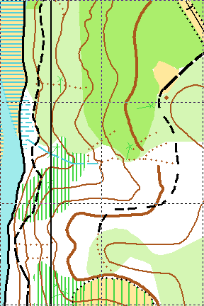
And now, this is the same area after the refresh. I do feel better now about me being lost there last year :-) Quite different, isn't it?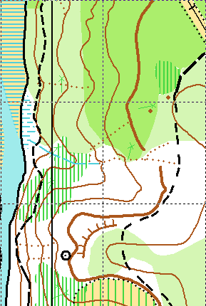
Sunday, March 9, 2008
Night-O at Lake Johnson
It was probably the coldest evening this week and I think everyone felt it. All three of us (Tanya, Michael and myself) were freezing on the parking lot for quite a while. I was fortunate enough to have an extra coat, but Michael wasn't prepared at all. I ended up giving him my coat just before the start. Tanya and Michael decided to go together on the easy course, while I chose the hard one. I am not running Reds as of lately because of my knee, but Score-O was fine because of the time limit. The knee can handle up to one hour of running, so it was good. Plus I really like Night-O events and usually do good there.
Jumping ahead, I did good this time too and ended up being second, but made several costly "strategy type" mistakes. The first one was right at the start: I didn't look at the points associated with controls and simply assumed that the ones across the road are the only ones important. My strategy was very simple:
1. Take everything across the road
2. Then go along the main paved trail and pick up a few more controls as time allows.
And I did just that.
But if I had looked at the control points I would definitely take 15 pointers 55, 56 right after the start and 18 pointer 58 later on. But I didn't. Too bad...
Anyway, according to my strategy I went down to the parking lot, crossed the road and started to look for #70. I couldn't find it... It was probably the only control which wouldn't reflect the light unless you are 2 meters from it and looking right at it. Yes, it was very close to the trail, but down below the cliff. This control ended up being really bad for me (see below).
OK. I didn't find it, lost 1-2 minutes, but decided to proceed and pick it up on the way back, which was right thing to do. The rest of the controls in that area were good. I divided them into 2 clusters:
1) 72, 71, 73, 75, 74
2) 76, 79, 78, 77
Took one cluster, then another. Because of the initial flaw in the strategy, I was literally alone while taking all of those. I only saw other runners on 78 (Ken and Terese?) but that was it.
All right, after I finished these clusters I went back to my #70. And what do you think? I couldn't find it again! This time I spent 5 minutes there, running back and forth this trail section. That was my second big mistake, I should have just go and forget about #70. But I stayed and paid dearly for that. Not only I lost a lot of time there, but also when I finally found the control, I fell of that cliff and re-injured my bad knee. Ouch... No mapping today in Schenck Forest and a big question mark on the next 2 events...
After #70 I hobbled to the parking lot and stopped there deciding whether to continue or finish right there. I had 24 minutes left, but the knee was kind of loose and in moderate pain. Tried running on the parking lot and it felt OK, so I continued according to my initial plan.
48, 57, 49, 50, 59, 65... all along the main paved trail.
A funny thing happened to me at #57. This is the one which wasn't set correctly. Naturally, I didn't find it, ran by and then started to look around with my flash lite. And bingo, there was a prefect reflection 50-60 meters away. Yay, I ran there only to discover a park post with a reflecting number. LOL. I looked back and saw someone with a flash lite approximately in the area there the control should have been and ran back there. What do you think? It turned out to be Joseph resetting the control.
Anyway, at 65 I had 8 minutes left and decided to turn back toward the finish. Correctly took another route and picked up 54, 53, 52 and 46 along the way. Ended up 2 minutes late and extremely exhausted.
Tanya and Michael had already finished (they did quite good by the way). My knee was loose and hurting, so after a few minutes of rest we left for the car. Along the way we saw people helping Ruth, I am glad she ended up OK (if not counting stitches...) after that fall.
Finally, here is my route (click on it to see the full picture).
Thursday, March 6, 2008
Crab Tree Lake Event is coming !!!
I knew that new map was ready, but I had no idea Josef was going to do the event there that soon. What a pleasant surprise! March 23 - sprints at Crab Tree Lake. I am really looking forward to it. Not being a fast runner, I still think it will be a lot of fun, especially with possibility to run twice and discuss the course with others between the runs.
On a sad side, it looks like I got some kind of nasty infection in my abdomen and may have to walk the March 8 Night orienteering course instead of running it. That would be a pity. I usually do very well on the night course... Hopefully, the antibiotics will start working by then, but I am, as they say, cautiously pessimistic about it...
