As I promised before, here is the first part of my "mapping in the Bond park" saga. Comparing with the map refresh I did in Schenck forest a year ago, this one (though a refresh too) proved to be much more difficult. I think I already spent as much time in the Bond park as I did in Schenck forest and I am only about 50% done. There were several things that complicated this map refresh work for me:
- The base map was indeed very old and outdated. Not only the trails has changed, but also vegetation and terrain.
- There were several big construction projects completed after the base map was created. Community Center, Seniors Center, new boat house, new parking lots had to be added to the map along with appropriate changes in elevation lines.
- This time I decided to map vegetation (white/green/dark green areas as well as fallen trees), which I didn't do in Schenck forest.
Anyway, here is what I did (step by step):
1. November 5
Went to the park and talked to Tracy (park's manager?). She gave me permission to map the park and in general was very supportive. She would love to have a new map with a set of their fixed controls plotted on it. She also gave preliminary OK for our sprint event next year.
Then walked around the park and compared it to the base map. Oh, boy. So many new constructions! Also noticed that the dam at the lake was plotted on the base map 5-7 degrees off! Here is a portion of the base map which was updated the most.

2. November 6 - 13
Spent the next week by working with the aerial image of the area and moving new features to the base map. 5 most affected areas were:
- Community Center
- Seniors Center
- Fenced area with tool shacks and equipment
- Additional parking lot
- Restrooms by the parking low

Here is an aerial image I used (it is a few years old). I took it from Cary Parks web site (I checked Google maps too, but it had "summer" picture, which is hard to use because of tree shadows).

3. November 17
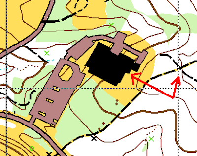
I went to the park and compared my "aerial like" map of the Community Center with the real Community Center. It was clear that the whole block with the Community Center and parking lot was somewhat misplaced:
- It was too close to the road on the left
- The building was too big
- The building wasn't aligned with the trails intersection (see arrows on the map)

4. November 23
I finally was able to place the Community Center "block" correctly, so it would correspond to the western road and eastern trails.
Also fixed the outlines of the fenced area and reduced the "garden" south from the fence. The "garden" was actually plotted on the base map with a "25 yards" mistake. After that my trust for the base map accuracy completely evaporated and I started to double check every feature on the map. (Jumping ahead, I indeed had to fix several similar errors in other areas of the park later on)

5. November 24
With Community Center properly is place, I was able to do more refined work in that area. Put new trails and open areas on the map. Note though that the elevation is not fixed there. I haven't done it before and didn't even know where to start, so I was putting it off.

6. November 25
More refining work (still afraid to touch elevation lines):
- Mapped intricate details inside the Seniors Center (I wonder why, we shouldn't be running there anyway)
- Added the "greenhouse" area
- Made the first pass on vegetation south west from the Community Center (as you will see, I re-did this part a few weeks later)
- Mapped the scary "impassable" area (again re-did it later)

7. November 30
My first attempt to put correct elevation lines in place!
Not the final one, but it was a big step for me. From that point on, I at least wasn't afraid of doing it. And practice makes perfect, right?

I guess it is enough for the first part :-) More to come...

No comments:
Post a Comment